Sunday, December 31, 2017

Another Circuit of Mount Alexandra

I am somewhere along the Nattai River, head down, covered in cobwebs, burrowing through spiky regrowth, 
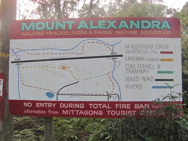
supposedly on THE circuit route of Mount Alexandra that is shown on the faded old map at Lake Alexandra, and, I've lost the track, again. I recross the creek, look upstream, nothing, then back downstream – my foot tracks in a bit of clear sand by the river bank but no other indicator of passage. The book I have access to - “Discovering the Southern Highlands on Foot” - did mention crossing to the south bank of the Nattai River, so I go back again and fight my way through scrub, and, there a few metres above me is a vague track heading east, found again.

This was supposed to be an easy jog around Mount Alexandra on tracks, following this route that is displayed at Lake Alexandra, but, reality is not much like the sketch map. It all looks so clear and straight forward on the map. On the ground, it's a little different. The track along the Nattai River is overgrown and tough to follow and there are confusing track junctions all along the way and scant track signs. Below is my best guess of how to navigate the circuit without getting too terribly lost. I did have to backtrack a couple of times to “refind” the track.

Gibbergunyah Creek

Starting from Lake Alexandra, follow the paved track around the west side of the lake and take any one of several bush tracks that all join the main fire track that heads northwest along the eastern branch of Gibbergunyah Creek. Look out for a cement post with the top painted red that marks a foot pad descending to the creek. Follow this track until it joins another fire trail, and turn right to follow Gibbergunyah Creek north under the Hume Highway.

The next junction is easy to miss so keep an eye out for steps descending down to the creek on your left only a few minutes after passing under the Hume Highway. There is a sign, but it is down the foot track and not easily seen from the fire road. Cross Gibbergunyah Creek on a narrow cement foot bridge and head downstream with the river bank on your right. It is not very far to another sign where you cross the Nattai River on slimy rocks. Immediately across the river, the track actually forks, although it is virtually impossible to distinguish either fork. There are two signs, one pointing steeply up out of the river bed to the left, the other fallen down and buried in bush directs the walker to the right along the Nattai River.

Crossing the Nattai River

The track is hard to follow here as it is overgrown with fern and fallen trees. Keep the Nattai River to your right and look out for another crossing of the river to the south bank. I had to scout around to find the track here, maybe you will have better luck than me. When you do find the track, you'll be on the south side of the river with the river on your left. If you are counting, you have now crossed creeks three times in total.

For the next kilometre, the track is very overgrown and you'll be pushing through scrubby bush, climbing over fallen trees and trying not to lose the foot pad again. Gradually, the track gets clearer and easier to follow and you come out near a scraping where coal has been dug out. A steep track climbs up here, but the circuit continues straight ahead and, if you are on the right track, you should find some track markers along the next section. The track heads north following the river around a big oxbow and you are actually going away from Mount Alexandra at this point.

These signs could be superfluous if the track were cleared

Eventually the track turns back to the south and starts heading towards the highway and Mount Alexandra again. Soon, you can see the big highway bridge and you might begin to think all the tricky navigation is over, but it's not.

Pass under the Hume Highway (about 2 km east of the first passage under the highway) but don't take any of the tracks that climb up to the highway (at least one is marked by flagging). Instead, stay low and cross the Nattai River again on rock slabs. With the river on your right, follow the track as it climbs up to a viewpoint of 60 Foot Falls (often dry).

Upper Nattai River

Soon, the track joins a fire track. You should be heading south now with Mount Alexandra on your right hand side. The fire tracks gradually merge with other fire tracks but keep heading south and you'll be on track to return to Mittagong. You can take the low route and contour (on fire roads) around the south side of Mount Alexandra back to Lake Alexandra or you can grab a bit more training and hike up the Coke Tunnel track (look for the track to your right just after a fire road junction) back to the upper parking lot, then up the lookout fire track to the Boulder Valley track and back that way.   

Thursday, December 28, 2017

An Alternate Circuit of Mount Alexandra

If you walk around the NW side of Lake Alexandra, you will find a mouldy map showing a circuit route of Mount Alexandra. You could do this loop, which is just under 8 km long but you'll only accumulate, at best, about 100 metres of elevation gain. Here is a better circuit that runs over Mount Alexandra and garners about 400 metres of elevation gain in just under 6 km.

Follow the track around Lake Alexandra until you meet the main fire track heading NW along Gibbergunyah Creek. Turn left and continue along the fire road until a cement post (faded red top) marks a foot track that descends down into the creek valley on the right. This section is really nice along side a verdant creek with scattered sand-stone outcrops above.

Soon, the foot-track rejoins a fire track where you turn right and travel north along the east bank of Gibbergunyah Creek. Just before the track passes under the big highway bridges, a steep track climbs out on the right hand side. Follow this up to the top of Mount Alexandra, detour to Katoomba Lookout if you have not been before, and then continue down hill to the upper parking lot on Mount Alexandra. Watch for a cairn on the right as you descend as you will be coming back here later.

Behind a mangled gate, a very steep fire road runs generally southeast down to the lower edge of the reserve. Follow this downhill until you meet another fire road, turn left and look for a small track to the right that runs downhill to meet the main fire-road in the Nattai Valley. Turn left (north) and follow the fire track until you encounter the coke tunnel track on your left. The junction is unmarked but if you reach the fire road to 60 Foot Falls you've gone slightly too far.


Hoof it up the steep coke tunnel track back to the upper car park and keep going until you are almost at the top of Mount Alexandra again and look for the cairn on the left that marks the uphill end of the Boulder Valley track. Turn left and saunter down this track until you cross the fire road you started on and wander back to Lake Alexandra.

Tuesday, December 26, 2017

Around Mount Alexandra

I'm trying to keep jogging along the top of a road cut above the Hume Highway my feet on a mesh basket filled with rocks and the roar of Christmas holiday traffic assaulting my ears from 30 metres below. I would hate to topple down here; my head would be squashed like a ripe watermelon under the wheels of a speeding car, piloted by a hung-over, hypoglycemic father who already wishes the kids were back at school.

Why am I even here? This was supposed to be a training jog up and over Mount Alexandra, along the Nattai River, and back over Mount Alexandra all on tracks. Somehow, as so often seems to happen, I've been lured off the map, off the track, bashing through the bush because I don't want to go back.

Katoomba Lookout

It's surprisingly easy to find yourself off the map in the bush reserves around the Southern Highlands. I don't understand it. The little towns along this stretch of the Hume Highway must be wealthy – houses sell for millions of dollars - but the local reserves and parks are poorly maintained, ill-signed, and generally unloved. The district tourist information office does not even have a map of the local area tracks, focusing instead on pimping food, wine, and consumer goods in a nation where too many people are overfat and drowning in debt. As usual, money trumps everything.

But I am both figuratively and literally off track. From Lake Alexandra, I followed a bush track (if you look carefully you will find a broken down sign pointing to the Boulder Valley track on the uphill side of the fire road that heads west from Leopold Lane) uphill to the rounded top of Mount Alexandra. If you plan on coming down this track from Katoomba Lookout, watch carefully as there is no sign and only a fallen down cairn among greenery to mark the track. The Boulder Track joins a fire road that leads from the upper parking lot to Katoomba Lookout, but I turned right, away from the lookout, and jogged down to the upper parking lot.

Tunnel

A signed! track (“coke tunnel”) runs straight down the east slope of Mount Alexandra after passing through a coke tunnel. This track is very steep, eroded and joins the northern end of Leopold Street down near a tributary of the Nattai River.

I followed this fire road north to the 60 Foot Falls fire road junction where I stupidly took the verbiage on the sign “No Through Track” as literal truth and ended up followed Leopold Street to its terminus beside a big talus field above the Hume Highway. No problem, climbing over a fence I could see a bit of a track traversing the talus so I kept going. I knew from a previous trip that another steep track came down the NW ridge of Mount Alexandra to Gibbergunyah Creek which was only a kilometre away.

Then, the track and the talus ended and I was on the road cut above the Hume Hwy. Contouring west I found a steep paved drainage gully which I slithered down until I emerged on the Hume Highway. Gibbergunyah Creek bridge was now a mere 100 metres away so I jogged along the highway to that, but, the highway bridge is about 70 metres above the creek and the track under the bridge with no easy or even safe way down.


Heading back, I found another drainage gully this time heading uphill and west, so I scrambled along that until it ended, then headed into the scrappy bush. Some easy bushwacking, a clamber over a fallen down fence and I was on the track that comes over Mount Alexandra. I had not previously been right down to Gibbergunyah Creek so I hiked down the steep, but constructed track to the fire road where I even found a sign. From there, it was a simple matter to hike back up the track past Katoomba Lookout and back down the Boulder Valley Track.   

Wednesday, December 13, 2017

2018

2017 is slipping through our fingers as quickly as a rational thought slides off the angry orange man's cerebral cortex. That means it is time for Doug and I to wish you all health, happiness, and sustainability for 2018. We hope you enjoy a few pictures and stories from our last year, but we would get greater pleasure from hearing about your 2017, so please send us your Christmas letters and pictures.

Wild islands off the Queensland coast

March was extraordinarily rainy in eastern Australia, and it wasn't until the end of March that we got away in our caravan again. We paddled out to Broughton Island, a favorite with sea kayakers, then detoured south to climb, canyon and bushwalk in the Blue Mountains World Heritage area.

Doug in pagoda country, Blue Mountains area

Heading north we visited a series of wonderful National Parks in northern NSW where we descended into steep sided rock canyons, followed brumby paths along meandering rivers, and walked beside precipitous rocky spires.

Deep in Oxley Wild Rivers National Park

Queensland was mostly about sea kayaking. Over a series of multi-day trips with different groups of friends we covered around 800 km of coastline, with literally hundreds of humpback whale sightings.

Whoa!

Our earth is precious, as is our health, look after both in 2018.


Looking down on kayak camp

Monday, December 4, 2017

#Vanlife And Training: TFTNA, Transition Phase

#Vanlife, apparently trends well. Certainly, people seem to think our lifestyle - living in a caravan and wandering around the country engaged in an endless series of outdoor adventures - is pretty awesome. And, mostly, #vanlife is very good. In fact, I have got so used to the constant novelty that is #vanlife that I get twitchy if I am in one place for more than a week. But, just like every other lifestyle, #vanlife is not perfect. The big downside of #vanlife that has triggered Doug and I to start looking for a real home is the inevitable physical degradation that accompanies long term #vanlife.

#vanlife

Reality is, adventures are great, but, without regular systematic training, you lose strength, aerobic fitness and flexibility. Even the great Stevie Haston has commented on how weak he gets on long climbing trips. The side-bar, of course, is that Stevie Haston is one strong dude and his weak is most people's strong. But, I am not Stevie Haston, and, at 54, I have to protect all the strength, conditioning and mobility I have.

#vanlife and #training

In an effort to “be a better human” (my standard response when people ask me why I am training) I bought House and Johnston's book “Training For The New Alpinism (TFTNA),” carefully read the book through and developed my own training plan. Now this might seem a bit of a strange choice after my last blogpost, but, if I were Steve House fit, I would feel that I had met my goal for being a “better human.”

Bouldering in the shire

The training approach is classic linear periodization with a big emphasis on building a solid aerobic and strength base. Unlike typical endurance training programs, aerobic capacity and strength are trained concurrently. If you are fit and strong already, a non-linear approach, such as the one described by Steve Bechtel, is probably superior (at least in terms of year round climbing performance), but I am neither (fit nor strong).

Big pack, no track, thick bush

The first training block (the Transition Phase) lasts 6 to 8 weeks and is basically two endurance sessions a week, two general strength sessions a week, and one day climbing. Without going into too much boring detail, training volume and intensity gradually increase up to week 8 at which point volume is halved for one week (deload) prior to the next training block. Of course, training without attention to diet leaves at least 50% (possibly more) of your potential gains on the table, so there is also a recommended diet.

Bacon and eggs before a ski day in the Monashee Mountains

Without a recent history of this type of training, I had to estimate my training hours using the guidelines in TFTNA. That got me started at about 5 hours a week, increasing to around 6 hours by the end of the Transition Phase. Looking back over my logs, I actually did about twice that amount of training per week if you count all the additional Zone 1 exercise I did each week. My two biggest weeks came in at around 20 hours per week, but, as all but 30 to 60 minutes of that was at Zone 1, it was not overly stressful.

Guy Fawkes National Park

The two structured endurance sessions were surprisingly easy, if going slowly, so, so slowly is ever easy. For the first couple of weeks I had no heart rate monitor and had to guess at intensity. Once I got a heart rate monitor, I realised I had been way out of Zone 1 and had to slow right down. My jogging pace – no way I could call it running – at Zone 1 is so slow that were I more susceptible to shame it would be embarrassing.

In the Budawangs

As an aside, TFTNA recommends doing a maximum heart rate test (easily done with a steep hill and a heart rate monitor) rather than using standard formulas. But, I am a fan of Phil Maffetone and the Maximum Aerobic Function (MAF) approach so I used that formula. I suspect all the various formulas and tests come out fairly similar.

Training stairs, Blue Mountains National Park

Anyway, I went from never doing anything more than walking (albeit I do a lot of walking) to jogging for up to 1.5 hours at a time with no real issues. For a couple of sessions I did switch from my usual zero drop, zero padding shoes to a more regular running shoe as I had a slightly irritated shin, but this quickly resolved. Also, I had no problem doing these sessions fasted, although I was ready to eat afterwards.

Kanangra Tops National Park

Which is a perfect segue into the diet aspect of training. This was really easy for me as I have been following a real food diet for well over 8 years now, so I had already stopped eating sugar, grains and industrial seed oils. My standard diet would generally be considered ultra-low carbohydrate by conventional standards and I can easily go many, many hours without eating (Google “fat adapted”). I did find, however, that I performed better on the strength sessions with a bit more carbohydrate than normal so I actually ate at least one piece of fruit a day, and sometimes a little potato or white rice.

Sandstone climbing can be brutish

And that leads me back to the strength training sessions. In the Transition Phase, there are two strength sessions per week of alternating upper and lower body exercises preceded by a series of trunk/core exercises, starting with 1 round at week 1 and culminating in 4 rounds at week 7. These were tough and left me most fatigued which is not surprising as #vanlife is quite congruent with maintaining endurance but not at all conducive to maintaining strength.

Fooling around on Marshmallow Sea, Arapalies


Recovery from strength sessions takes a frustratingly long time as you get older and I found two strength sessions per week once I got up to three rounds hard to recover from. I recovered best with four days off between sessions but that means only three strength sessions in a fortnight not four. For a concrete sequentialist, who likes everything divided neatly into standard seven day weeks this requires difficult mental gymnastics and I continued to train twice weekly in the Transition Phase.

Focus, El Portero Chico, Mexico

In a similar struggle with mental gymnastics, I found it hard to NOT train to failure during my strength sessions and this may have contributed to my slower recovery in the later weeks of the Transition Phase. Overall, however, my numbers (reps and weights) did go up over the Transition Phase.

Cascade Mountains, BC, Canada

Instead of climbing one day per week, I went paddling instead. This was solely geographic. Right now we are near the ocean, but over two hours drive from any climbing. In less than a week we will be about five minutes from a well developed sport climbing crag but a long drive from the ocean, so climbing will be in and paddling out. I'll also have access to some legitimate hills to train on instead of having to plod up and down the single 40 metre hill near where we are staying.

Tollgate Islands, NSW

Finally, what I would do differently next time:
  • Go somewhere nice for the long endurance sessions even if it means getting in the car and driving. I avoid driving at all costs and so did most of my endurance training from the neighborhood where I am living. There are some good trails around here but about half my endurance training time was taken up getting to the trail through residential  neighborhoods. Around week 6, I decided to drive a short distance to the local forest to train and it was so worth the 22 km round trip that I wished I had done so much sooner.
  • Avoid the temptation to train to failure on the strength sessions. Training to failure is great for hypertrophy, and I plan on doing a hypertrophy phase next, but, it should not be a component of the Transition Phase.
  • Space strength sessions out for optimal recovery even if this does not nicely fit into a one week format.
  • Manage stress, however you do that. I walk a lot, hence my 22 hour training weeks.
Gorgeous forest for those long runs


Friday, December 1, 2017

Alpinism

For some bizarre reason, one of my blog posts about kayak surfing has generated a series of comments about the extent of alpinism (aka mountaineering) in Australia. Now this is odd on two fronts, one, my blog has very few readers (Hi Mum) and two, the post in question is about sea kayaking, a sport that every Australian should participate in, but which is, in fact, not that popular. Readers, before you inundate me with comments about how your 98 year old Aunt Gladys goes kayaking every Wednesday, note that I am not talking about paddling a sea kayak on enclosed waters, I am talking about sea kayaking on the open ocean.

Launching into small surf on the south coast of NSW

But, I digress, as do the readers who argue about alpinism in Australia in posts about sea kayaking. So, back to alpinism in Australia. Reading over the comments left regarding alpinism in Australia, the arguments in favor are:
  1. There are "mountaineering schools" in Australia.
  2. Many states have mountain ranges.
  3. Skiing is challenging in Victoria.
  4. Tasmania has difficult ranges for skiing, ice climbing and hiking.
  5. The Australian Alpine Track is difficult to ski.
  6. Australia has produced many alpine skiers who participate in international competitions.

Ski touring in the Purcell Range, BC, Canada

Obviously, if one is going to argue about alpinism, one must first agree on a definition. I define alpinism in its classical sense that is climbing high and difficult mountains that are snow and ice covered most, if not all, of the year. Clearly, I could end this blog post right here as Australia simply does not have the geo-climatic conditions to meet this definition (excluding Australia's Antarctic regions). Even Tasmania, which is close to Antarctica has no permanent snow fields and only sporadic snow cover over the very highest (around 1600 metres) mountains.

Sir Sandford, Columbia Mountains, BC, Canada

However, I do dream one day of being paid by the word, so instead of ending this blog post right here, I'll take each argument in turn.
  1. There are mountaineering schools in Australia, and, apparently, they teach introductory mountaineering skills such as walking with crampons, use of an ice axe, etc. The Australian School of Mountaineering will even take you for a snowshoe walk to the top of Mount Kociousko. I'm sure it's all great fun and a good learning experience but the existence of courses teaching introductory mountaineering skills does not mean that Australia has any significant alpinism.
  2. There are mountain ranges all across Australia, from the arid rocky McDonnell Ranges of the Red Centre to the scorparia covered ranges of Tasmania. They are all beautiful and I have enjoyed hiking up mountains in all Australian states. But, for the most part, none of these ranges has significant alpine climbing, see my definition of alpinism.

Now, I can just hear readers beginning to sputter "but, but, but, what about Federation Peak in Tasmania?" Yep, Federation Peak is by Australian standards a big mountain with a long and tedious approach, and, if you waited for the worst day of winter and climbed Blade Ridge you would be a genuine bad-ass and you would experience alpine conditions, but doing so would be somewhat (a lot) contrived and not truly representative of alpinism.

  1. Apparently, Jake wants me to know that skiing is challenging in Victoria. I expect it is given that the average snowfall at Mount Hotham is under 2 metres in the entire season. This is about half what used to fall in my backyard in the interior of BC in winter, and a mere 1/7 of the 14 metres that my local ski hill gets every winter. This low snowpack undoubtedly makes for challenging skiing as obstacles are barely covered and approaches from the valley must be done by walking not skiing.
Now, as Jake rightly points out, I have not (yet) skied in the Victorian Alps, but, I have walked all over them, just as I have walked and skied over large tracts of mountainous terrain in Canada and the United States. Australian mountains have their own beauty, but, they are not the mountains of alpinist.

  1. Tasmania does indeed have difficult ranges for skiing, ice climbing and hiking, but, again, that does not make Tasmania an alpinists playground if you define alpinism as climbing high and difficult mountains that are snow and ice covered most of the year. Most notably, the reason Tasmania has difficult ranges for skiing is because there is insufficient snow cover for most of the winter to actually ski. A certain snow depth is required to cover obstacles and permit skiing.

  1. The Australian Alpine Track is difficult to ski. Given the elevation of the track for most of its length can this really be a surprise to anyone? One of my Australian friends "skied" the Alpine Track and reported that it was bloody hard, mostly because he had to carry his skis almost all the way. Difficult yes, alpinism, no.

  1. Finally, Australia has produced many fine downhill skiers who participate in international competitions. Honestly, I have no idea what this has to do with alpinism?

Humping big packs across the Badshot Range, BC, Canada

Now, on a general note, readers seem to take umbrage from my statement that ski mountaineering and alpine climbing are difficult to do in Australia. And, it is absolutely true that ski touring is possible, hiking, scrambling and rock climbing up mountains are also possible, but true ski mountaineering and alpinism - as they are classically defined - are just not a geo-climatic realities in Australia. This is not in any way a derogatory statement, merely a statement of fact. Australia has many beautiful wilderness areas and many special places. The geo-climatic conditions between Australia and Canada could not be more different, but the sense of adventure and exploration that is gained by venturing into wild places is strikingly similar.

Brinkley Bluff, West MacDonnells, NT, Australia

I have now spent roughly half my life in Canada and half in Australia. I love the mountains of Canada, the deep snows that bury the evergreen forests and the high mountain peaks. But, I also love the wild unceasing surge and suck of the Australian coast, the blue haze of eucalpyt oil in the summer sun over the Australian bush, the arid red rocky mountains of central Australia, the deep gorge country cut by rivers, and the sculpted beauty of sandstone cliffs. To truly thrive as humans we need wild places and we need adventure wherever those things are found.


Morning over the Southern Ocean, Victoria, Australia

Saturday, November 25, 2017

In Search of Montague Island

A friendly seal popped his head up right near my kayak as we paddled out of Wagonga Inlet and an unfriendly Maritime boat almost ran over Doug near the bar entrance, but soon after these two events we were heading southeast with light winds and low swell. The lighthouse on Montague Island was just visible 10 km distant and floating eerily in a misty sea fog. But, it was a case of now you see it now you don't as, within minutes, the sea fog had rolled right across the horizon and sky and sea met in a blank sheet of grey.

Friendly seal near Narooma bar

We paddled on for another 15 minutes, scanning the horizon constantly for a glimpse of the island or the lighthouse, but ocean and sky seemed merged in to one quietly heaving liquid form. Of course, I had forgotten the compass, again. Doug suggested we paddle for an hour and then check where we were with the map on our mobile telephone, and this seemed like a reasonable suggestion, so we groped along for an hour in the deepening fog. Soon, the fog rolled right over us and settled on our skin like a clammy blanket. I kept mistaking rolling ocean swells for land and the denser the fog became the louder the waves sounded crashing on the rocks to our right.

In search of Montague Island

After about an hour, we checked the map on the 'phone and found that we had travelled much further south than east, and were only about a kilometre off-shore. We needed to travel due east, a direction we could only roughly pin-point. Doug thought we should simply paddle down to Mystery Bay and skip Montague Island but I, ever the optimist, thought the fog looked to be clearing so we decided to paddle straight into the wind – which now appeared to be easterly, not northerly as reported - for another 15 minutes.

Arriving at Montague Island

Within 10 minutes, a ghostly stretch of coastline appeared, enough to convince of us we could find the island, and within 20 minutes, we were in bright sunshine again. It took another hour to reach the island, paddling all the way into a light headwind. We reached the island a little south of the lighthouse and were immediately greeting by the caw and cry of wheeling sea birds, and the splashing of small seals. The water was wonderfully clear and a few seals were very curious and followed along behind our boats for half a kilometre, jumping and splashing over and under our boats.

Meet and greet the local inhabitants

The north end of the island has big granite slabs that slope down into the sea and this is where most seals congregate. The bulls are obvious, big and usually barking, they are surrounded by a harem of females. When the screams of gulls and shearwaters mingle with the bark of seals, the result is a wonderfully loud and discordant cacophony.

Swimming under our boats

We paddled along the northern shore and down the east side of the island where you never see any other boats. Even in a low swell, the east side of the island is bumpy with random haystacks as a steady current always seems to be running past.


At the south end of the island, we unfurled our sails and sat back for a fast ride to Mystery Bay in the predicted 20 knot northerly. Initially, we were sailing along briskly, but, just as quickly the wind gradually decreased and then died altogether. By the time we reached Mystery Bay, there must have been all of 1 knot of wind. It was, however, another wonderful day messing about on the ocean in a small boat.   


Sunday, November 19, 2017

The Parable of the Bombora or Ulladulla to Mosquito Bay by Sea Kayak

Day 1: Ulladulla to Bawley

Nine sea kayaks are lined up along the small beach inside Ulladulla Harbour. The briefing is short, but complete, spoken in plain English, not in perplexing parables. About half of us know this section of the coast relatively well: where there are sheltered landings and campsites, where reefs and bomboras pick up the swell. There are one or two bruisers in the pod, but most of us are cruisers and this is definitely a cruiser trip.

Legitimate Bruiser

There is some talk of the long period swell and allusions to bomboras and reefs, but the general plan is to paddle out around Warden Head and turn south with a lunch stop at Crampton Island. Paddling around Warden Head, the sea is as calm as I have seen it, except for the occasional big roller rumbling through. Usually Warden Head is a mess of clapotis and rebound, but today it is pretty smooth. There is just enough wind to sail and the paddle south to Crampton Island is uneventful, apart from a seal at Warden Head.

Surprisingly calm Warden Head

It is easy to land on the north side of Crampton Island for lunch something even the bruisers on the trip can appreciate. Often, we land on the north side of Crampton Island and paddle out on the south side, but today the rip that usually provides easy passage is very narrow, and occasionally breaking big, so we head out to the north again before turning south.

Crampton Island

Near Bawley Point, John scopes a reasonable landing just north of a rocky headland and he paddles in to confirm the landing is reasonable. However, we have neglected to discuss a signal before hand so John, after waiting a while for people to land, paddles back out again to tell us the landing is fine. It's a big group and a reasonably narrow easy landing zone so it takes some time for everyone to get ashore. I am getting better at waiting out the back for my turn to land instead of crashing through decapitating other paddlers as I blunder blindly towards the beach.

The crew near Bawley

We carry our kayaks across the sand to a small lake and paddle upstream to a delightful campsite shaded by she oaks. In the afternoon, the group disperses, some paddle the lake, others practice eskimo rolling and I, of course, walk. I find a good forest track that takes me out to an exposed headland and north to another quiet lake.

Hauling kayaks

That evening, as we sit around cooking and eating, John relates the “parable of the bommie:” The story of a young kayaker trashed by a surprise wave near Green Island on the south coast. We all sit around in hushed silence like kindergarten kids at story time. How many of us think “that could be me?”

The pod waiting for a signal from John

Day 2: Bawley to Murramurang

It is a morning when a competent kayaker should be able to get off the beach without getting their hair wet, yet, when I go to launch, my boat gets pushed sideways, and the rip current starts sucking me towards a rock reef. I have to power out without regard to the oncoming waves and take one full in the chest.

Another bruiser on a cruiser trip

We paddle south with a good tail wind even this early in the morning passing Bawley Point and down to Brush Island where we paddle between the island and the mainland. All the times I've paddled this coast and we always go inside Brush Island. I need to go back and paddle around the eastern side.


As we approach Kioloa, Belowla Island resolves itself into an island distinct from the mainland. Mindful of the parable of the bommie, I give a wide berth to the sloping rock platforms of Snapper Point and O'Hara Head. Sometimes these platforms break further out than expected. Just past Dawsons Islands, John paddles into Snake Bay which frequently offers a surprisingly sheltered landing site, although the beach is very small. We have a short break here with Durras Mountain looming above.

Snake Bay

This is my favourite section of the coast. Mostly national park with only a couple of small settlements; it is a green coastline, small rocky bays and tiny sandy beaches overhung by gorgeous spotted gums. There are half a dozen little islands, hidden beaches, and sheltered landing spots if you know where to look. There is an influx of tourists over the summer months, but for most of the year, and especially in winter, it is gloriously empty.

Leaving Snake Bay

From Snake Bay we paddle south in a brisk northerly wind. Point Upright is impressive as always and we are ripping along surfing down wind waves with puffed out sails. Durras North almost always has a sheltered landing and we are stopping here for lunch. As usual, there is a little traffic jam as 9 kayaks surf into the beach and I somehow get caught on a curling wave behind Karen.

Point Upright

Amazingly, we are both caught by the same wave, but at different times. Karen capsizes but rolls smoothly back up, while I teeter on the brink of a capsize, caught off-balance watching Karen. I almost manage to brace back up but make the rooky mistake of keeping my head up, instead of down, and, after a long moment caught in limbo, I too am upside down. My roll, unlike Karen's is not consistent and I have to exit the boat and swim in.

Not sure how I managed to swim here

The wind has risen while we are having lunch and the afternoon's paddle is just about perfect. The wind and swell combined make the paddling engaging but not too terrifying and I feel like I am riding on the perfect cusp of adventure where the challenge is just great enough that you aren't completely confident that you can succeed. This is the place where the magic happens.

Having fun

All the beaches in the Murramarang National Park have a south facing component and most have steep beaches with dumping swells that can make landing a kayak challenging. As usual John goes in first to check out the landing conditions. I am impressed, as always, by John's extensive sea kayaking knowledge. He comes back from the first beach saying “We will have swimmers,” but successfully lands on the second beach and holds up a paddle to guide the rest of us in.

Beach master John

Determined to redeem myself, I follow John's instructions assiduously, paddling hard after a big waves passes and getting over the first break easily, and then side-surfing the second wave into the beach. There are two swimmers, and one errant paddle, which Tony rescues and styles the landing while paddling with two blades in his hands.

Tony bringing back a lost paddle

We have a perfect campsite on level grass under steep cliffs. I walk up in the gorgeous gum forest behind the beach under towering silver barked spotted gums through ferns and burrawang palms with lizards scurrying off into the undergrowth and kangaroos bounding away. The wind slowly subsides and the beach slivers golden as sun sets.

Evening Light

Day 3: Murramarang, Tollgate Islands, Mosquito Bay

There is a big roll of clouds spiraling along the coast when we launch but within an hour or two, the cloud is gone and sun is back. We paddle south with no wind this morning, past headlands and small beaches. Near North Head, my timing while weaving through a rocky reef is just slightly off and I have to paddle hard not to get hit by a breaking wave. When I pull out the other side, John is shaking his head: “That closed out completely behind you” he says, obviously wondering if I have already forgotten the parable of the bombora.

Morning on the water

A couple of people paddle through the wave washed slot near Three Islet Point but I pass by this time thinking that I have used up one of my escapes from bommies already. We have a leisurely break on Judge's Beach looking out to the Tollgate Islands and then with a light snifter of wind, paddle south out to the twin Tollgate Islands.

Everyone loves the Tollgate Islands

We point out the Blue Cave to the non-locals and I am surprised that even John is not going in today but the swell is a bit northerly and the dark, narrow defile looks as evil as it ever does. We wander around the islands, watched by a curious seal, paddling into small bays and passages and finish up on the south side of the island near a big sea arch.

The infamous Blue Cave

John, Steve and Jenny take turns backing gingerly in under the arch, and then Tony backs far into the back just as a bigger set comes through. He side surfs and slips about in the wash and breaking waves, but makes it out without any damage to body or boat.

Steve preparing to enter the arch


From the Tollgate Islands, we sail down to Black Rock some of us passing to the east, some to the west. I am happy to be out on the water with my tribe away from the slow-drip stress of looking for a house, and paddle around the east side wondering how long I can spin out this wonderful trip away from connectivity, away from the world. But, paddling around the south end of Black Rock, I see kayaks with sails flying heading in towards Mosquito Bay and I know that another trip is over.