Sunday, June 22, 2014

Gamboling Up Gubara

Our last day in Kakadu National Park we followed Gubara Creek up onto the convoluted plateau north of Nourlangie. A good gravel road (9 km) ends at a parking area and track head to access the creek. The last 300 metres of road to the parking area is rough, so it is just as easy to park in a large circular pull-out and walk the short distance to the track head. At the "official" parking area, the wooden signs had been removed, and a couple of pieces of paper loosely sellotaped to a post indicated that the "signs are under maintenance." There was some other verbiage on the sheets of paper, describing the distance and the need for a permit if you are going to camp, but, the most notable feature is how familiar this form of repair is in Kakadu National Park. The campground we had left the caravan at similarly had the fee collection box "under repair." Doug wondered out loud how long the paper signs would last. Not long, it seems, as they had all fallen down by the time we returned that afternoon.

Shady Monsoon forest in Gubara Creek

The first three kilometres is on a good track, the best we have walked on in Kakadu, apart from the short tracks around the art sites. Most tracks look a bit like this picture below which was taken on a billabong walk but could have been taken anywhere. There is a scant footbed buried under there some where and, if you are taller than me, and taller than the three metre high spear grass you might also be able to see a track marker. The Gubara track, however, is clear and comfortable to follow, at least in the cool of morning. At 3.00 pm when the air is dripping with humidity, it is not that comfortable, it is, however, still easy. 

Typical Kakadu track

Near the end of the track, a big metal footbridge spans a dry creek. A wooden sign (not yet burnt to a cinder or removed for repair) indicated the pools are to the left. If you are wondering what lies straight ahead I can tell you as I explored it a short distance on the way back out. A surprisingly good beaten in path leads through boulders to a dry creekbed and up onto some flat rocks above a small dry waterfall. Beyond that, you are on your own. The creek is shallow, dry and provides no easy passage into the spinifex and vegetation choked valley beyond. Short broken cliffs are scattered up either side of the shallow valley. This valley would give passage to the higher lands above, but it would be a battle.

 Doug in Gubara Creek

We, however, turned to the left and followed a beaten in path through a thicket of palms to a small pool on Gubara Creek where we had breakfast. The most logical place to wander for the day was up Gubara Creek which is shaded by monsoon forest, and relatively easy to travel. The creek itself is in a short gorge for the first two kilometres but the bottom is open, either boulders or sandstone ledges. Travel is not what you would call fast, but it is painless and interesting. Early on, a steep sandstone wall would offer fabulous climbing in a shady cool location. A bit further up, the roots of a large tree lay like a bundle of snakes across the rocks. Further still, and a short waterfall is encountered, and soon after a deep pool which is easily circumvented via rock ledges on the left. Finally, just before the short gorge disappears altogether there is one last waterfall which is easily scrambled on big sandstone ledges. 

 Doug below the cliffs in Gubara Creek

Suddenly, the gorge has dissolved and the creek forks into two smaller tributaries. The right hand one is dry soon after the junction and in a couple of hundred metres becomes narrow and bushy. The left hand fork still has water, but rapidly becomes narrow and vegetated. On either side, turrets, spires, and corridors of sandstone cliffs are laid out in echelon formation making a maze of passages, tunnels and corridors. We scrambled out of the left hand fork and after wandering through sandstone corridors found a short pagoda like cliff onto which we could climb. The surrounding terrain, while not holding great vertical relief is incredibly complex. Vegetation of varying degrees of vigor is wrapped around and into every little crevice and corridor. A labyrinth of sandstone towers, turrets, boulders, pagodas and small escarpments lies criss-crossed across the terrain. We had lunch while pondering the difficulty of navigating and travelling through this almost impenetrable terrain and understanding more and more why 
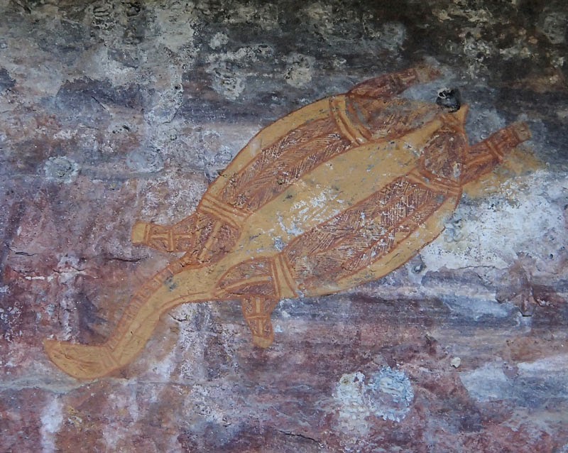
the aborigines routinely burned the understory vegetation in the top end of Australia each year. Walking through the scratchy, irritating understory, I feel like lighting a fire myself. 

 Scrambling on the Gubara Plateau

You could keep walking up on the plateau here, although, this upland terrain is not a level plateau rather it is higher country than the low level floodplains but rugged and jagged with variously eroded sandstone formations. A common multiday route in the area is to hike east to peak 424 on the Arnhem Land plateau. Apparently, at least early in the dry season there is plenty of water and there are indigenous art sites scattered all over the place, but, such a trip is for the hardy and experienced. It's easy to underestimate the difficulties of traveling through this country. 

 Above Gubara Creek

Tuesday, June 17, 2014

Unselfconscious Selfies on Ubirr

At the northeast end of Kakadu National Park, bordering Arnhem Land which is reached by crossing the inimical ford across the East Alligator River at Cahills Crossing is Ubirr. What makes Ubirr popular with the tourists are the fantastic view across the Nadab floodplains of the East Alligator River from the top of Ubirr, the outstanding examples of indigenous art, and the possibility of spotting a "saltie" from the viewing platform at Cahills Crossing.

 Nadab Floodplain

We arrived at Merl campground in the early afternoon. Like all the facilities in Kakadu, the campground has gone past tired and is now well into decrepitude. In the bathroom block, water leaks from pipes in the roof and has been "mended" with adhesive tape; and mended about as well as a water pipe under pressure would be fixed by adhesive tape from your local newsagents. The toilets are either out of order, or so full of spider webs that you are afraid to sit down. This is the country, after all, where 90% (or some ridiculously high number) of the worlds most poisonous insects are endemic, so, unless a spider can be conclusively identified as a harmless Daddy Long Legs, it seems wise to be suspicious. This is all a real shame as the campground is otherwise very nice with big private sites each with a table (and a fire pit, more is the pity). The mosquitoes, once the sun goes down are horrendous, but this is Kakadu, and to expect anything else would be foolish.

 Long necked turtle

We had time to wander, on a poorly marked track out to Cahills Crossing from the campground where the tide was rushing out over the crossing and a bunch of indigenous folk were fishing from a rapidly rising sandbar in the river. The East Alligator River is silty silver with mud as it rushes 5 km upstream from the weir, which is itself 70 km upstream from the Timor Sea. The tides here average about 7 metres - a lot of water to move up and down four times a day. 

 Looking towards Arnhem Land

At 4.00 pm, we went up to the Ubirr art site as one of Njanjma (indigenous) Rangers was giving an evening talk. I imagine it is pretty hard for black fellas, subject to intense discrimination across the country, to give a two hour talk to a white mob, but this young man managed very well. He told Dreamtime stories, explained the rock art, and talked about how the indigenous population gathered and hunted food across the Kakadu area before the influx of white man. The art at Ubirr is rich and complex. In some areas, up to twelve layers of paintings overlay one another. Most is on low easy to reach sections of the cave walls, but, one intriguing and intricate drawing of sorcery figures is high up on the roof overhead. The aborigines believe Mimi spirits, who are tall and thin, lifted the rocks down, painted the figures and then set them back up again. Standing atop Ubirr with the verdant green wetlands spread out below, jagged sandstone towers on the horizon, ungainly Jabiru launching into elegant flight, prehistoric reptiles preying in the silty waters of the tidal river, and the ever present rowdy call of the cockatoo ringing in the air, it is easy to believe in mythical beings. 

 Mimi spirit figures

The contemplative nature of the sunset moment, was, however, spoilt for me when I turned around and confronted a dozen out of shape white fellas unselfconsciously snapping "selfies" of themselves seemingly ignorant of the magnificence of their surroundings. Have we always been so absorbingly self-obsessed or has our too comfortable life divorced from the natural world and lost in crowded cities promulgated the me generation? Would we still be drawn to cave paintings from a lost era if they featured exclusively realistic self-portraits of the artists instead of communicating Dreamtime stories of creation and emblematic representations of mythical spirit creators? Perhaps, it is just another indicator of our crackbook culture wherein, if we don't photograph it, post it, brag about it, and, most importantly, get credit for it (in the form of "likes" and "thumbs up") it never happened. 


Jabiru Dreaming

I left Doug cooking up some eggs and bacon in the caravan and headed off just after 7.30 am to walk the Bardedjilidji Track and the Sandstone and River Bushwalk. The Bardedjilidji Track is a short, well marked track which wanders through sandstone towers and makes a loop back along the East Alligator River. The latter track, branches off the former, and follows Mawoene woene Creek south before traversing across country to return north along the East Alligator River. At the Bowali Visitor Centre we had been told that there was a seasonal closure still in place on the Sandstone and River walk as the rangers hadn't been along it to declare it open this year. Given the state of the "track" I don't think the rangers have been along it for many a year, and, frankly, I doubt that they could find it any more, but more on that later. 

 Cahills Crossing

My first stop was Cahills Crossing where the river was low, but the tide still rushing out over the weir. It was quiet in the morning. The usual daily influx of aboriginals across the river had not yet begun and the barramundi fisherman were still lying abed dreaming of their catch. I spent some time looking for saltwater crocodiles but the water level may have been too low. I wandered upstream past the upstream boat ramp where a gleaming truck pulling a boat trailer advertised "Kakadu Fishing Safaris." Later in the morning, Doug saw them parked on the Arnhem Land side of Cahills Crossing. Apparently, the clients paid big bucks to motor a hundred or so metres downstream and essentially fish where the aborigines cast out handlines (with more success) for free. 

Salwater crocodile in the sun

The Bardedjilidji track wanders through interesting sandstone towers and outliers, past deep caves and crevices. Gungadbow (Jabiru Dreaming) dominates the view to the west rising above dense green wetlands. Just before the Bardedjilidji track splits at the wet season/dry season junction, a very faint track branches off and a sign indicates "seasonal closure." This is the route to the Sandstone and River walk. My first foray took me off to the right following two very faint wheel tracks through thick dry grass. This track forked, one branch running out to the road and a sign prohibiting entry (these signs pepper the National Park and seem mostly meaningless) while the other ended swiftly at some low sandstone outcrops. Retracing my steps, a bit of wandering about resulted in my locating a large and sturdy footbridge across Mawoene woene Creek. Various signs indicated the danger of swimming in this water, although I doubt anyone would risk a dip in such a turgid black pool.
Once across the creek, the track should, if the maps are to be believed branch left and right. The left branch quickly reaching the East Alligator River and the right taking the longer route along Mawoene woene Creek. There was no sign of any track to the left, so I duly went to the right. 

 Tunnel track

My baseline of what constitutes a decent track has swiftly declined since arriving in Australia. Now, anything vaguely marked by any indicator at all, no matter how sporadic, widely spaced, decrepit or rusted, or with even the slightest hint of a foot bed, no matter how deeply buried beneath dense vegetation is considered a "good track." It may go straight up crossing fourth class terrain with fearful exposure, or descend so precipitously that fracturing a femur, pelvis, spine, or perhaps all three is likely in the event of a slip, but, if the track is at all visible, it will still meet the criteria for a "good track." This track did not. 

By travelling in what I generally considered the right direction - quite difficult to establish as I had no topographic map, and the three sketch maps I had managed to source from various different track signs were all different - I would eventually manage to spy, in the far distance, buried in tall spear grass, a faint and rusted track marker. The walking was mostly not at all enjoyable. The grass was thick matted and tall - sure to harbour some incredibly toxic Australian snake. I believe, but you can Google it to check, Australia has more poisonous snakes than any other country, and, given that I see at least one snake on every bush walk, I am undeniably, and I think sensibly, nervous of snake bite. Underfoot, which I really couldn't see, the ground was full of ankle twisting holes and hollows, some knee deep but completely invisible. I'm not sure if they were all made by rampaging water buffalo - just another creature to be aware of out here - or whether they are the dens of toxic snakes, but, they are certainly ankle snapping. Eventually, I managed to bash on until I reached a second footbridge shown on one of the three maps I had garnered. I could only risk short glimpses at the photos of the sketch maps I had on my camera as my battery was rapidly waning and these rough line drawings constituted my only navigational tools. I did note, however, that this second footbridge was only an eighth of the way along the circuit. At this rate, I would still be on the track tomorrow. I passed a small scattering of rocks, which could have been the rock outcrop marked on one of my sketch maps but just as easily could be completely insignificant. 

 Sun over wetland

I confess at this point I was considering the "sunk costs" of this expedition. On the one hand, I was continuing on because walking back was unappealing, but, walking the entire distance risking darkness falling, snake bite and being charged by a rabid water buffalo was no more appetizing. Mostly, I was thinking about how Doug was also walking this track and I feared he would come back and say "What, you didn't find the track? It was perfectly clear."
At some point, it all became moot. At a last rusting track marker, I searched ahead, and out to each side in a reasonable facsimile of a sensible Search and Rescue grid search (as taught by Nelson SAR) and could find no other marker anywhere. It was with some relief that I turned back, carefully trying to retrace all the little foibles of the geography that I had noted on the way out should I have to return. As an aside, I was once on a Nelson Search and Rescue training weekend where we (the hapless new recruits) were given to believe that we were heading out to "practice" bushwacking on the second day of the two day weekend "extravaganza." I left before that session. The idea that one would willingly subject themselves to bashing through the BC bush "for practice" was an anathema to me. In my time in the West Kootenay, I bashed up and down over a hundred peaks, and certainly had no need to "practice" bushwacking. The technique is simple. Put your head down and wack. Practice not required. 

 Jabiru Dreaming

In any event, I duly returned to the first long and robust footbridge and set about searching for the left hand branch of the track, which did not exist in any form, something that was no surprise to me, nor should it be to you. Finally, I made my way back to the tourist track on the Bardedjilidji circuit. Once on that track, I scrambled up a rock pagoda and had a break from all that wacking as I watched the tourists trundle around the loop below me.
Walking back along the East Alligator River I passed a small, circular, dark pool where a freshwater crocodile was resting on the rock bank. Fumbling with my camera, I scared him (?her) off his rock perch and he disappeared below the ebony water. Shortly thereafter, I saw a big estuarine crocodile lying on the opposite bank in the grey mud of the ebbing East Alligator River, and, further downstream, near Cahills Crossing, another estuarine crocodile floated lazily in the drifting waters. 

After spending some time at Cahills Crossing; quite a crowd had gathered by now and were watching as one white fella pulled out a series of barramundi for a bunch of black fellas, all of whom were happy to get their own fish for dinner, I meandered downstream onto the Manngarre track. 

 Wetlands

This short circuit walk has been hacked into dense monsoon forest on the western bank of the East Alligator River. There are a series of viewing platforms but most have grown in so thickly that the river can only be glimpsed through the foliage. I did, however, at the "womens' place" on the trail, see yet another estuarine crocodile, this one swimming up river with some determination. By the time I returned yet again to Cahills Crossing, the run of the river had switched and the silvery grey water was rushing up over the weir. A "cheeky" (as the aboriginals would say) white fella, in a work truck on his way to some job in Arnhem Land, drove out into the writhing water, feeling cocky, as white fellas are wont to do, and almost lost his truck in the turbulent water as it began to float at the deepest part of the crossing. Given that there were by my count at least three saltwater crocodiles now upstream, swimming out of a lost vehicle here would be quite a proposition. Finally, with swollen feet, in the heat of the day, after wandering about, thoroughly enjoying myself for the last six hours, I wandered back along the track to enjoy a well earned cup of tea at the caravan.

Saturday, June 14, 2014

Barrk Sandstone Walk

The Barrk Track may be the best half day walk in Kakadu National Park, which, may not be setting the bar all that high, as despite covering 20,000 square kilometres, there are a dearth of walking tracks more than one to four kilometres long. The loop walk is supposed to be 12 km, but as we did it in about three hours, at a lackadaisical pace (we do everything in the heat and humidity of the Northern Territory at a lackadaisical pace) with a few stops, I don't think it is really that long. Nevertheless, an early start makes the walk more pleasant, particularly as it starts with a sweaty climb up to the Burrungui Plateau. 

The Burrungui Plateau (called Nourlangie Rock by white fellas) is, as far as I can make out without a topographic map, a series of higher sandstone cliffs and escarpments spread across about 24 km square kilometres. Along the base of the escarpment, large caves and overhangs have sheltered indigenous people for generations and now preserve some of the finest indigenous art in the world. 

 Burrungui From Anbangbang Billabong

The walk starts out following the tourist track past Anbangbang Shelter, Incline Gallery and Anbangbang Gallery. In all these locations there is evidence of past aboriginal occupation in the form of paintings and rock art, much of it layered over generations. After the Anbangbang Gallery, the track climbs a little and short side walk takes you out to the big sandstone pavement of Gunwarddehwarde Lookout (the aboriginals have a penchant for repetitive multi-syllabic names) overlooking the flat savannah lands to the south and in the shadow of the higher Burrungui Plateau. 

 Sandstone pavement

A sweaty climb follows up onto the plateau top, largely following the route of a dry creek as it runs down from a cleft in the plateau, but weaving about around big rock outcrops. Near the top of the plateau another big sandstone pavement gives higher views over the savannah. I expected a big National Parks, "Turn Back Here" sign at this location, but, surprisingly, there is nothing.

 Sandstone formations

Now the track weaves around the plateau past towers, turrets, and spires of layered sandstone. You wriggle between boulders, pass through narrow crevices, and scramble over slabs. We had breakfast on a flat tower looking north to the ocean, the flat savannah resembling a great inland sea. The track drops a little and passes over a higher flat "valley" before reaching the northern end of the plateau where another descent down another dry creekbed leads out onto the lowland savannah. The walking is faster and easier here, without big rocks to scramble around and the track is clearer. Shortly, the junction with an old road is reached and a short climb to the south leads to Nanguluwurr Gallery. Some of the paintings here were done in the 1960's by some well known and prolific local artists and feature the newer X-Ray line style. Others date back a long time and are simple hand sprays, yet others depict sailing ships, likely from the late 1800's. Strange arms, wrapped in intricate designs are thought to represent lace gloves seen on European women. 

 Aboriginal art

From the Nanguluwurr Gallery it is supposed to be six kilometres back to the parking area, but I suspect it is more like four. The track passes under impressive cliffs and roofs of the Burrungui Plateau (climbers are drooling, except for the heat), climbs gently over a small ridge, and, shortly you are back at the parking lot, having an early lunch in the shade of a picnic shelter.

Sandstone Wandering In Kakadu National Park

The night before this walk, I had one of those tortuous dreams that seem to go on and on with no resolution and strange, unrelated people popping in and out at odd moments. In this dream, I was planning a sea kayak trip and had great difficulty getting topographic maps which I eventually procured. Trouble was, all kinds of people, including my dad (whose been dead almost 30 years), my oldest brother (who would no more paddle a kayak than climb a mountain) and various other unidentified but bothersome people kept trying to mark up the maps. I awoke after a bout of screaming "no one is to touch the maps." Clearly, the fact that the only map we had for our travels through Kakadu National Park was a road map was deeply troubling to me. How I longed for a set of topographic maps of the Northern Territory.

That was the night before the walk, the day before the walk, we had driven an hour (to cover about 18 km) down a rough corrugated road to Gunlom campground where Waterfall Creek falls 70 metres over the escarpment into a deep plunge pool and eventually meanders out to join the South Alligator River on the low lands. A steep but substantial track leads up to the top of the falls and a couple of beautiful clear pools in the small sandstone gorge. Many out of condition travellers were staggering up this slope, mostly glad in highly unsuitable thongs (something you wear on your feet in Australia, thankfully, I could not see their underwear), luckily, they happily stepped aside to let us past or it would have been a tedious 70 metre climb. 

 Above Gunlom Falls

The pools are beautiful, but the walk seems too short, so after dashing back down for a swim in the plunge pool at the bottom, we hiked back up again - great consternation from people that we would actually hike twice up a whole 70 metres, and went wandering. Fresh from Umbrawarra Gorge, the sensible thing seemed to be to follow Waterfall Creek east across the plateau. We did this for about half an hour, but it was on the bushy side, and we felt closed in under the dense (for these parts) forest. A shady ledge above the creek offered a good lunch spot and a view to rocky escarpment on either side. We abandoned our course up the creek and instead, wandered up rocky slabs and over boulders to the ridge line above the creek. From the top, we had a good view across Barramundie Creek to the Arnhem Plateau, but a topographic map, to plan a walk and identify all the terrain features we could see, would have been helpful.

 Looking towards the Arnhem Land plateau

The next day, we started out optimistically enough to walk what the National Park literature describes as an unmarked route that makes a circuit around Kurrindie and Motor Car Creeks and the South Alligator River. We packed long pants expecting tall spear grass. The first part of the walk is on a trail and leads through savannah forest along the northern edge of a sandstone escarpment. After about 4 km, a side track leads up to a deep pool at the base of Motor Car Creek falls, now just a trickle over black cliffs into a deep, dark pool at the base. We were expecting a long day so did not take the time to swim just walked back down the side track and changed into long pants as the track ahead had deteriorated to a small swath through high spear grass. It is only about 1.5 kilometres along this narrow track to Kurrindie Creek and a side track, that disappears at a minor tributary drainage leads part way up to Kurrindie Creek falls. The last bit you must scramble up big river boulders to another deep plunge pool before another trickling waterfall. We were hot and bothered by now so we did have a quick dip in the cool water before walking back to the "main" track. A few steps further on, and all signs of a track disappeared.

We pushed through head high spear grass to Kurrindie Creek and began to follow it downstream, through thick spinifex, matted spear grass, and spiky sword palms. Progress was not only slow, but painful and tedious. After a bit, we battled our way through spear grass out onto some sandstone slabs above the east side of the creek. "It's all a bit ordinary" we said to each other. An Australian expression that means it's actually bloody awful. I spied a strange mushroom shaped sandstone tower above the river and we decided to head for this eminence for lunch. Much battling with spear grass followed and we were somewhat relieved to climb out onto clean sandstone slabs below a big undercut mushroom of rock. Doug did a few pull-ups to celebrate and we sat down to lunch in the shade. 

 Celebratory pull-ups

Once again we got to wondering if it wasn't better to walk up on the sandstone plateaus rather than down in the river beds. To the north of us, extensive slabs of sandstone led up to some small peaks on a plateau above both Motor Car and Kurrindie Creeks. After lunch, by picking a route on boulders and slabs, we had a minimum of bush and quickly ended up onto a big flat open plateau overlooking Kurrindie Creek. We wandered north, scrambling up and down gullies between sandstone slabs to the furthest north plateau looking over the South Alligator River and down to Motor Car Creek. A topographic map would have been great to have. 

Instead of going back the way we had come, we plotted a route past a small mini escarpment to the left, and a gentle hillock to the right that, if we passed both and headed almost due south would allow us to intercept the track. Most of the way was good travel. We could link together boulders and slabs, and even a creek bed that ran in the correct direction for a while, but the last 15 minutes was fairly scratchy. Scrambling down one section over a shadowy cave, I scared a Barrk (a dark coloured male wallaroo, apparently fairly rare and infrequently sighted) out from its resting spot in the shade and it took off showing us it's muscular black body quite unlike other wallaroos and kangaroos. 

 Above Kurrindie Creek

The last half hour, and particularly the last 15 minutes was quite ordinary. We were out in the savannah grasslands and the spear grass was matted, dense and over my head. Pushing through, I would collect a big bow wave of snapped off stalks which I would have to eventually push aside before I began to accumulate more. When we finally pushed out onto the track, our arms were scratched and itchy with the spear grass rash. 

Spear Grass

We took the time to walk the extra distance up to Motor Car Falls for a swim in the deep pool before staggering the last four kilometres back under the baking hot sun. I saved a few sips of water for the short side walk that led to Yurmikmik Lookout which we did for completeness. The view was nowhere near as good as that from our wanderings on the Callanan Claypan along the sandstone plateaus.

Monday, June 9, 2014

Reinventing

A half moon was in the eastern sky as I walked up the steep road from camp. At the height of land, I left the road and pushed through high dry grass to the edge of the escarpment and scrambled up knobbled sandstone towers until I was higher than the tallest tree and could look out over the valley below. Mesa tops were stained red by the setting sun, kangaroos were thumping through the savannah after drowsing away the hottest part of the day, and the calls of night time hunting birds were replacing the warbling of the lorikeets. Tonight the moon would be bright enough to walk in the open without artificial light.

 Smitt Rock, Nitmiluk, walk or paddle only

I was sweaty, grimy and dusty, ready for my night-time wash in the cool river water before escaping to the relative comfort of our little caravan. One of my climbing friends, still young enough to be dirt-bagging it around North America, working only when she needed cash for another climbing trip, once said "people don't realize how, if you are outdoors all the time, sometimes it is nice to just go inside." A concept I immediately understood as the mark of a real outdoors person. Not the kind of hang around a campfire with a cold beer in one hand, eating packaged food and sleeping on a mattress that is so large it must be inflated by running an infernal combustion engine, "outdoor person." Rather, an outdoor person whose life is marked by at least some privation and discomfit. Perhaps working hard on the land through heat, humidity, rain, wind, cold and snow; or wandering in the outdoors by choice, climbing, skiing, hiking, paddling, yet suffering the same extremes of temperature. 

 Paddling the Newry Islands

It is almost two years since Doug and I owned a home, or had a permanent address. Almost two years since we moved from Canada to Australia and began living a vagrants life in a caravan. Sometimes, I feel as if I am reinventing myself. I no longer climb mountains, but I paddle an ocean kayak from island to island across a tropical sea. I haven't skied for two seasons, but I have hiked through rainforests, across dry plateaus, along rugged coastlines. I still climb, although now almost exclusively on steep sandstone escarpments. I still live the life of an outdoor person, suffering privation and discomfit enough to enjoy the relative ease of our caravan after a week sleeping on the ground in our small tent carrying our gear on our backs or in our kayaks. 

Solitary sunset

Occasionally, we will meet other Australians who ask, "what is the most wonderful place you have been?" and, I'll be dumbstruck. Was it walking the remote southern coastline from NSW to Victoria with southern storms pounding on the endless sand beaches wrapped up in jackets against a blustering wind? Possibly it was kayaking the rugged east coast of Hinchinbrook Island with the towering mountains wreathed in sea mist above and dolpins playing in the sheltered bays? Or island hopping through the Coral Sea to arrive at a sheltered aquamarine lagoon on Lizard Island in the far northeast as colourful corals slid under the kayak? Maybe it was ridge-walking past stunted snow gums on an interlocking web of ridge lines above the iconic Snowy River under the raucous laugh of the kookaburra? Was it an eternal series of sunsets over the western sky from an endless series of remote beach camps reached by sea kayak? Or perhaps the searing red gold of the sunset sky above towering Blue Gums in the pristine Grose Valley? 

 Big ocean, small paddler

In the end, I can't really say, but, it was somewhere reached by foot or paddle, far from the infernal combustion engine, where the night sky is so bright with stars that you have no need for artificial light. A place which requires some sweat, some muscle, some dirt, some grime, and a healthy feeling of fatigue to reach. A place where you lie down to sleep when it is dark, and rise with the dawn. A place which you leave with sadness and return to with joy, and which, long after you have left, remains deeply etched in your mind.

Antifragile In Umbrawarra Gorge

With one hand, I balanced my pack on my head, released my grip on the rock walls of the steep red rock gorge and prepared to swim 200 metres to the end of the deep, narrow defile. Only problem is, I immediately sank, gulped in a lungful of water and, choking and spluttering kicked hard with my legs, flung the now soaked pack back up onto the rock ledge and gasped out "well, that didn't go quite as planned."

We were at the western end of Umbrawarra Gorge having walked along the plateau top from the campground to a narrow, shallow side gorge that disgorged a small amount of water out into the main flow of this tributary of Stray Creek. A half hours walk upstream through dense stands of pandanus, flaking paperbark and knee high native grasses had led to this long narrow stretch of gorge filled with clear green water and flanked on either side by steep red sandstone walls worn smooth by annual floods. 

We had arrived at the small campground in Umbrawarra Gorge Nature Park on a Thursday afternoon with just enough time before dark to wander up to the first two pools. There are some "established" rock climbs on the walls of the gorge above the first two pools, although in this instance, established may simply mean someone once climbed a few lines here and gave them names. There are no bolts, no anchors, and, on many of the routes, precious few gear placements. After a few weeks however, of staring at climbable rock where climbing is banned, we were keen to climb at least a few pitches, despite feeling desperately out of shape for tackling Australian sandbags. 

 Top-roping an Umbrawarra Route

It was around 11.00 am the next day when we could climb as we needed to wait for the gorge walls to come into the shade. Climbing in the sun is completely out of the question as you literally could fry an egg on the sandstone walls. The tops of the walls roll back and are littered with loose blocks, large and small, so we were limited to climbing routes that were (a) within our rather mediocre current grade level; and (b) had a nearby tree anchor. This left us with three routes. Doug led one nice jagged crack climb, which enabled us to top-rope another steep and fun face climb. We also managed to top-rope a rather unusual route up a series of overhanging horizontal flakes and roofs. This one had a huge high-step onto a steep roof above that was just too high a step for my old weak body and I had to do a pull-up to get my foot onto the crucial hold. The final move was a classic mantle onto a small ledge. It was fun to be climbing again, and we climbed all the routes a couple of times, sucking the joy out of them. A small crowd of early weekenders had gathered at the base and I heard the voice of a small child say "she's stuck," as I paused at the mantel move. "Not stuck," I called down, "just temporarily paused." 

Next day we decided to walk up the gorge to the end, which, according to our road map (how I longed for a real topographic map) was about 4 or 5 km. We got a somewhat delayed start as Doug had started out in a pair of very cheap, and rather nasty, river sandals and had discovered (again) that they were very poor quality and he was slipping and sliding on the boulders in the gorge bed. It was obvious he would sprain an ankle, twist a knee, or fracture a couple of femurs should he continue so he went back for better footwear. I dawdled around, swimming in a deep pool in the gorge floor and eventually, as I abhor being still, walking back to meet him. 

 Rock slabs Umbrawarra Gorge

The gorge is perhaps 100 metres high at its highest point. At the eastern end, it emerges from the surrounding dry savannah plains and rapidly increases in depth. The bottom is lined with large river rocks, some still featuring the ripples of an ancient sea, others washed smooth by wet season floods and inordinately slippery, particularly if your shoes are wet or sandy. Progress is slow as you cross from one side of the river to the other scrambling over boulders, along short sections of sandy beach, and up and down ledges of red river rock. Large burled paperbarks line wider sections of the gorge and spiky pandanus palms overhang the green waters. 

The further you go, the more isolated you feel, as the water gets clearer and deeper, the vegetation greener and more lush with pockets of ferns and sweet green grasses. Fig trees cling improbably to the gorge walls and send down thin snaking roots seeking water. The gorge twists and winds sinuously with side gorges running in at regular intervals. About an hour from the eastern end, the gorge makes a 90 degree bend at a deep sandy pool and the river runs under a tunnel of rock with a deep resonating gurgle. The red rock cliffs contrast strongly with the green water, and the entire gorge is eerily silent in this land where the screech of raucous birds normally runs through day and night. 

Quiet in the gorge

We stopped for lunch on a big shady rock ledge under an overhanging arch beside a deep pool at around 2.00 pm, realising that we would now have to turn around without reaching the end of the gorge. After lunch, I built a big rock cairn in the middle of the creek, and Doug built one on our lunch ledge on the north side of the river. We were already planning to come down from the western end the next day and wanted to see how close to the end of the gorge we were. 

Next morning, we started earlier but I tossed out the dry bag I was carrying for my pack. The three pools we could not circumvent the day before had reached only, at their deepest point, my neck and I had been able to balance my pack on my head, the dry bag seemed superfluous. Luckily, Doug still carried his small dry bag in his pack. 

  An easy pool to keep a pack dry

We hiked straight up hill from the campground to the plateau top and headed west along the rim of the gorge. One section, above the second pool, is for women only, according to the indigenous people who own this land, so Doug went well back from the gorge walls here to stay out of this culturally sensitive area. The flat plateau top is actually cross-hatched by shallow perpendicular gorges so every 10 to 20 minutes, you dip down into a gully and out the other side. There had been a recent grass fire so the ground was open for walking, only stunted eucalpyts remaining on the plateau top. The ground is so stony that I wondered how, or why, this land was used to run cattle, which surely must have trouble eking out sufficient food. There were flocks of birds in the trees, and the sandy ground between rocks was criss-crossed with animal tracks, but we saw no other living things. 

After about an hour and a half, the land began to slope down, and wandering out to the edge of the gorge, we could see the cliffs, while still continuing, decreasing in height. Just shy of two hours, we dropped into the shallow side gorge and eased out into the main gorge, the cliffs abruptly gone, the river spreading out over 100 metres and dense with native grasses, paperbarks and pandanus. We had reached the end. A half hour walking upstream as the gorge walls rose steadily beside us and we were at the long deep pool that marks this western end of the gorge. 

Doug looking small among big blocks

When we had both nearly drowned trying to balance our packs on our heads and swim with one arm, we realised that, if we were going to continue upstream and back to the campground we were just going to have to get everything wet. We stored our crucial gear in Doug's small dry bag, stuffed this into his pack, and, floating our packs with one hand, we swam with the other upstream, through the narrow gorge, past steep, smooth walls, and finally, heaved our now very heavy packs out onto a sandy bench at the eastern end. We were both reading a book by Nassim Nicholas Taleb (the author of The Black Swan) called Antifragile in which he argues that certain domains, and humans in general require difficulties to prosper. "We are having an "antifragile" experience, we joked to each other as we poured water from our packs and wrung out our dripping clothes and shoes. 

Half an hour upstream, after some easy boulder hopping and ledge walking, I pushed through tangled paperbark out into the river bed and confronted a large cairn right in the middle of the river. On the north bank, another cairn was stacked under a rock overhang. I laughed out loud at the serendipity of it. We stripped off our wet clothes, spread them out in the sun on the southern bank, and lunched at our "usual" ledge naked and in the shade. 

Far from the maddening crowd

Wednesday, June 4, 2014

"Doing" The Jatbula Track

"You can 'do' Nitmiluk National Park in a morning" said one of the grey nomads floating about in the pool with a kiddies pool noodle (though he seemed to have enough of a noodle around his midsection to keep him afloat) near where we had our caravan parked as we prepared for the Jatbula Track. "Easy," he continued, "drive out in the morning, take the 9 am boat tour and be back at the caravan park by lunch", and, presumably back in either the air-conditioned comfort of your caravan with the TV on, or floating about in the pool with one or more noodles. 

"Curses," I thought. We had just spent a day kayaking up to the top of the third gorge, another three days hiking to Eighth Gorge and Smitt Rock and here we were packing for another four day hike. All that time wasted when we could "do" Nitmiluk in under eight hours, not eight days as we were planning. Travelling Australians frequently talk of "doing" various parts of the country although it has never been clear to me how sitting by your caravan "doing" nothing can actually amount to "doing" anything. 

Morning at Nitmiluk Gorge

How can you have "done" Nitmiluk National Park when you haven't camped on the beach at Smitt Rock and gone swimming in the river after dark as shooting stars sear across the sky? Or walked across the dry stone country from waterhole to waterhole swimming under thundering waterfalls and camped by billabongs? Is it possible to "do" Nitmiluk National Park without seeing the aboriginal paintings tucked away in caves? Or not having scared up feeding lorikeets as you walk past in dense Mitchell grass? 

The Jatbula Track runs for 60 km from Nitmiluk Gorge to Leliyn Falls describing a wide arc around 17 Mile Creek and then following the Edith River west. There are campsites every 10 km or so, each situated by deep waterholes or cascading waterfalls. While there is no "formed footbed" the track is actually pretty good for most of the way, although there are occasional areas of swamp and dense vegetation. Blue arrows mark the route every 20 to 50 metres. Mostly, the track is easy to follow, and surely gets easier later in the season as more hikers complete the track and the tall grass falls over. Early in the season, some areas require a little searching about to stay on the track. The biggest difficulty is getting back to Nitmiluk Gorge to pick up your waiting vehicle as this is a one way walk. 

Day 1, Nitmiluk Visitor Centre to Crystal Cascades

For some reason, Parks and Wildlife and/or Nitmiluk Tours (who have the commercial aspect of Nitmiluk Gorge tightly wrapped up) have re-routed the track so that you now "need" to take a boat (Nitmiluk Tours) across the Katherine River to the start of the hike. This is a completely artificial barrier and, for deep philosophical reasons (a self-propelled activity should be self-propelled in as much as possible) we decided to circumvent this process. I won't detail here how we did it, but it is easy and adds only an hour to your walk. 

 The gorge below Crystal Falls

The first hour of the "real" walk leads along the base of the northern cliffs of Nitmiluk Gorge to arrive at the Northern Rockhole. In early June, the falls were dry apart from a trickle of water, but the water hole at the base is deep and cooling. We had the first of four days worth of naked swims. Five minutes after leaving the Northern Rockhole, the track meets a management track (another potential access track) and continues through dry savannah country to Biddlecome Cascades. The cascades fall in a series of small drops separated by deeper waterholes. We had lunch and another swim here. There is a campsite, but as this spot is only about 8 km from the start, it seems too early to stop. 

 Doug in the dry eucaplypt forest

We walked on another few hours to Crystal Falls, pushing through high dry Mitchell grass, past clumps of spinifex and alongside the bright orange flowers of woollybutt trees. About a half hour before Crystal Falls we stopped in a tributary creek and drank a full litre of water with electrolyte mix and had a quick snack. It was near 3.00 pm and baking hot under the tropical sky. At Crystal Falls, the first thing we did was strip off our sweaty clothes and plunge into the deep lily fringed pool above the falls. 

Day 2, Crystal Falls to 17 Mile Falls

Continuing from Crystal Falls, you either walk a long way to the next camp (27 km to Sandy Camp) or a short way to an intermediary camp (10 km to 17 Mile Falls). We opted for the short option and camped at 17 Mile Falls which absolutely should not be missed. The track crosses the creek (a tributary of 17 Mile Creek) and an overlook gives a view of Crystal Falls dropping into a deep narrow gorge carved into the sandstone where eucalpyt trees cling improbably to the rock walls. Easy walking across the grasslands where you can catch glimpses of the big broad 17 Mile Valley lead to the edge of a small escarpment on a tributary of 17 Mile Creek. A short side track descends to caves below where aboriginal art paintings are surprisingly well preserved as if the artists themselves had just stepped out to hunt goanna and kangaroo. Improbably, the interpretive sign describes the side track as "suitable for all and generally easy" seeming to ignore the fact that it is a day and a half walk to this junction. 

 Aboriginal art in The Ampitheatre

Another easy hour of walking leads to the campsite at 17 Mile Falls tucked under shady paperbarks on a sandy ground surrounded by slabs of hard, red sandstone. You can scramble down to the base of 17 Mile Falls on a rudimentary track (north side of the river) and swim in the large deep pools below. Under 17 Mile Falls the spray blows back into the air making rainbows and the rocks are worn smooth by flood waters. As the sun set that evening, the cliffs lit up red as forest fire and broad streaks of thin clouds streaked out above the eucalpyts. 

 17 Mile Falls

Day 3, 17 Mile Falls to Sandy Camp

From 17 Mile Creek, the track heads west across dry eucalpyt savannah to reach the Edith River. Early on, the track dips into a couple of narrow drainages where small amounts of water linger later in the year, but this is mostly dry country. A squadron of feral pigs trotted along beside me for a while before picking up my scent (pretty strong by this stage) and sprinting off. At Edith River Crossing, the river is still small and easy to ford, further west it swells in volume to fall over sandstone cliffs at Leliyn Gorge. There is some swampy ground and thicker bush in the riverine Edith River valley and I was dismayed to find my new hiking shoes soaked through with muddy water. Sandy Camp is a lovely site under large paperbark trees beside a big round waterhole on the Edith River. The water is cool for swimming and at sunset the trees surrounding the waterhole are reflected with astonishing clarity in the calm water. 

 Sunset swim at Sandy Camp

Day 4, Sandy Camp to Leliyn Falls

The last day of the walk follows the Edith River west to the Leliyn Falls. Immediately after leaving camp the track is hard to find in dense bush but within an hour the track emerges into dry open forest and is easy to follow. At a couple of marshy areas I took my shoes off and waded in ankle deep soggy mud to avoid wetting my shoes. There is a checkpoint but not much else at Edith River South and after about another hours walk, Sweetwater Pool is reached. 
 
This big deep pool on the Edith River has terraced rock slabs perfect for resting on after swimming in the clear cool waters. I expected to meet up with some day hikers from Leliyn Falls as it is only 4 km along a good trail to Sweetwater Pool - who wouldn't want to visit a place with such an evocative name? - but we only encountered two older folks out bird-watching. All the youth (and non-youth) had been unable to walk further than the upper pool from the parking area (just over 2 km return!). I'm not sure why I continue to be surprised by the sloth of the general population (young and old alike) but I am. 

Below Leliyn Falls
 
Around lunch time we intersected the Leliyn Loop tourist walk and took the long way back to the car park past the upper pool and Bermang Lookout. Here the river thunders with surprising force through narrow rock canyons separated by spilling falls. As always, it was difficult to end a trip into the wilderness. Life is just somehow better when each day requires nothing more of you than putting one foot ahead of the other, admiring the scenery and sleeping out under the stars. We had to wear swim suits for our final swim in the big deep pool under Leliyn Falls and listen to the grey nomads floating about with the ubiquitous pool noodles whining about how cold the water.

The car park at Leliyn Falls was distressingly empty as we were hoping to hitch-hike back, at least as far as Katherine. The price we had been quoted for a shuttle back to Nitmiluk Gorge ranged from $190 to $270 (everyone is making money on this walk except Northern Territory Parks and Wildlife who charge $3.30 per person for a campsite) and just didn't seem justifiable for a four day walk. Luckily, a very kind couple picked up a couple of smelly hikers with packs and took us all the way into Katherine. These kind folks actually offered to drive us right out to Nitmiluk Gorge even though they were not going that way themselves. From Katherine, we broke down and got a taxi out to the Gorge as it was getting late and we were wanting our dinner. 

In order of price, the cheapest fare we found for a shuttle was with Star Bush Taxi who quoted us $190 for the full distance from Leliyn Falls to Nitmiluk Gorge, Gecko (a local tour company) came in next at $250 (Gecko actually charges $55 per person but that is based on a minimum of four people), and finally, the local taxi company wanted a whopping $270 for the 90 km trip.

Unforgettable night skies