The
rain is sluicing down, the path is awash, ankle deep in parts, and
the trail resembles a wombat tunnel more than a track. How is this
possible, a mere kilometre from Currarong, a very popular tourist
destination with more Air BnB’s and holiday homes than permanent
residents? My cynical self thinks it has something to do with how
generally unfit and out of shape the denizens of the modern world
are. My less cynical side, well, I don’t have one of those. I
managed to tunnel my way to Whale Cove, Abrahams Head, Honeysuckle
Point, and Lobster Bay before running out of daylight and squelching
my way back along the main fire-trail which was well cleared but
still ankle deep with water.
I was staying the weekend in Currarong for a training weekend with
the NSW Sea Kayak Club. There were ten of us in all, two
instructors/assessors, two guide aspirants, and six other paddlers
who would act as participants, or victims, depending on your world
view. My goal is Sea Guide, while M is training for Enclosed Sea
Guide. There’s not a big difference between the skill set
required. Sea Guides must be able to launch and land a group through
one metre surf, but both types of guides have to be able to manage a
group in up to 17 knots of wind, and need to be both reasonably
proficient paddlers, be able to coach strokes and techniques, and
also have that elusive but requisite “situational awareness” or
“mountain sense,” as we used to call this uncommon way of
thinking back in my mountaineering days.

M led Sunday’s paddle, while I led Saturday’s paddle.
Saturday, was a pretty normal summer day, although it was autumn.
Sunny, warm with a building northeasterly wind. My assignment was to
take the group north from our launch site at Currarong Creek to a
stretch of beach where we could land and launch through the surf, and
then paddle back south, around Whale Point and into Honeysuckle Bay.
It’s hard to summarize in three to five points, how to land in
the surf. There can be so much to consider: is it a spilling wave or
a dumper, are there sandbars, what about rips, are there any rocks,
swimmers or other hazards nearby, what’s the best way to brace if
the kayak broaches, etc., etc., etc. CA, one of the assessors, has a
really nice short and effective series of tips that he communicates
before surf landings, whereas I tend to blather on like a chipmunk
hyped up on amphetamines about all the things a paddler could,
should, or might have to do.

In the end, everyone landed and launched without any drama which I
think was more testament to how easy the landing was, than my great
skill. While there was a series of waves to break out through, none
were packing that much of a punch. After relaunching, we paddled
over to Bosom Beach for lunch, and I, rather stupidly, let my guard
down and failed to prepare the group adequately for the moderate
northeasterly winds which were now steadily increasing.
We all got around Whale Point and into Honeysuckle Bay with no
drama and I attempted, with little success, to do some stroke
coaching. It was a bit windy, paddlers were bumping around and
having trouble maintaining their positions, and eventually, I got the
nod that we could head back.
The wind had increased a bit and the sea state was lively. We had
some minor drama paddling back around Whale Point. The GPS track
from my watch showed that we were 250 metres further off-shore than
when we had paddled around Whale Point an hour or so before. It
turns out that a lot of paddlers really don’t like paddling
broadside to sea and swell. Down here on the south coast, paddling
with a beam on sea is common. There was a capsize, but speedily
resolved as CA had dashed back and was assisting the paddler within a
minute or two of the familiar “paddler in the water” cry. I
herded up the rest of the group and we headed back into sheltered
waters. There seemed no point risking a second capsize by keeping
slightly unstable paddlers out in the freshening wind. We had a
magnificent feast for dinner and a pleasant evening sharing kayak
tales and listening to the wind blow around the house.
Sunday was M’s day and we left from tiny Honeymoon Bay in Jervis
Bay. Conditions were excellent if you like calm conditions and a
very low swell. We paddled easily past Longnose Point to Point
Perpendicular and then paddled back to Black Boat Cove (also known as
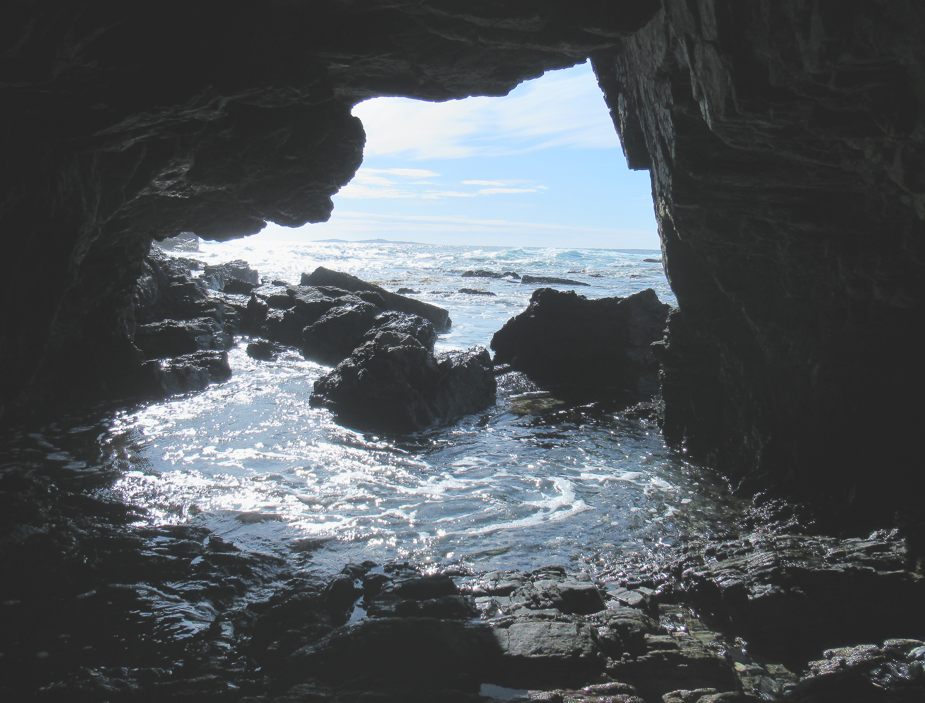
Boat Harbour) via The Corridor, a narrow tunnel through the cliffs
which is less than a paddle width wide. Everyone went through as CA
and A sat in their kayaks at either end. It was a first cave for
some paddlers!
Paddling out of Black Boat Cove the sky to the west was black with
clouds as a rapidly moving and strong front approached. Within
seconds, the wind went from calm to 25 knots with stronger gusts, and
pelting rain. Stopping to buckle my new hat on so I didn’t lose
it, I was immediately blown downwind and almost all the way back into
the cove. After getting the boat turned around and paddling back
out, I found I was far behind the rest of the group except for H who
was struggling to keep the bow of her boat pointed into the wind and
also struggling (with a too long paddle and poor stroke) to make any
headway. I paddled alongside H for a while, offering encouragement
and trying to keep her boat tracking mine but, we were getting
exactly nowhere and H was white with anxiety. My plan to put H on
tow was stymied as my paddle caught under my kayak and I almost
capsized!
As we were less than 500 metres from the shelter of Black Boat
Cove, I decided the smartest thing to do was run back downwind to
shelter where we could get ourselves sorted out. In all likelihood,
the worst of the squall would blow through and winds would ease. At
a minimum, I could switch my flat blade for my wing blade and effect
a tow. A was the only person within site, the rest of the group had
disappeared, so I tried to let him know our decision but I did not
want to leave H in case of a capsize so, after shouting for a while,
H and I ran back to Black Boat Cove arriving only a minute or two
before A.
I was concerned that H was cold so offered up some clothing but
she said she was fine and, as we discussed options CA arrived. CA
rapidly instituted a tow and with H paddling behind CA and me keeping
close watch on H, we made reasonable time. I was very glad to have
switched my wing blade for my flat blade and felt all the power that
a good paddle and stroke can give. A went ahead to gather up the
rest of the group who were sheltering under cliffs near Target Beach.
As we approached Longnose Point, we could see waves breaking out
to sea, wind waves, in other words. CA and I snuck around close in
to the point, with me keeping pace with H who I was still worried
about. As we rounded Longnose Point, large standing waves, 1.5
metres high reared up. I was talking to H, instructing her to keep
her bow pointed into the waves and paddle over them but she again was
white with fear. Soon, A came along and told me to go out front,
while he looked after H, and soon again after that, CA was towing H.
The marine chart bears the warning “Dangerous Ground, Breaks” and
indeed it does. If you were feeling confident, however, it was
actually quite fun paddling up and down over standing waves that were
almost like ocean rollers.
It felt like it took a long time to paddle the few kilometres up
what is called on the chart “The Groper Coast” to Honeymoon Bay
but my GPS track shows we were averaging between four and five
kilometres per hour. If you were comfortable in the conditions, and
not towing someone, the paddling was really fun. Finally, we reached
Honeymoon Bay. I lined my kayak up just outside the entrance so that
if people turned in right where I directed, should they capsize, they
would be washed harmlessly into the bay instead of into reefs on
either side. It was a happy group that landed on the small beach.