Wednesday, March 14, 2018

The Training Goes On


It's the beginning of March and the end of my 8 week base training block which, for a variety of reasons, morphed into an 11 week training block. In addition to training for life, I started training for a sea kayak trip which added two more training days to the schedule and left me training 6 days a week. However you cut it, training 6 days a week eats up a lot of time and some weeks I felt like I did very little apart from move around a lot while shifting weight. Officially, I was supposed to peak at around 11 hours a week, but I blew well past that and topped out in week 6 at over 19 hours a week.

Bungonia Creek

The basic schedule was much like my transition phase with two endurance sessions per week (on my feet), and two strength training sessions per week. In addition, I climbed twice a week, and, from week 6 on I added two paddle days (typically 25 to 35 km each day).

My Tribe: Kayak pod

To my utmost surprise, I got faster and fitter on my endurance sessions. Not fast mind you, but faster. Somehow at week 6, I managed to run, actually run (Zone 3) for about 1.5 hours on a hilly course covering 13 kilometres! Shocker. On my longest Zone 1, I covered 20 km and 500 metres of elevation gain all before breakfast!

Forest wandering

No real injuries, but I did have one week where I had mild hip bursitis which resolved quickly with rest but I did miss almost a full week of training (hence the expansion from 8 weeks to 11 weeks). My feet and calves were getting pretty sore with all the volume on hard ground but a new pair of zero drop but padded (Altra) shoes have solved that problem.

Quality hill training terrain

I seem to be managing OK recovering from strength training sessions by spreading them as far apart in a one week period as I can although I am training essentially to failure as I'd like to put on some muscle. The gym I joined has a climbing wall as well as a great weight set up so I can now boulder twice a week if we don't manage to get away climbing.

Tianjara Falls

In the midst of all this training we got away on a couple of trips, paddling from Boydtown to Bermagui, and climbing and canyoning up on the southern tablelands. Hauling a heavy pack with a fat rope out of Bungonia Canyon, I was glad I had been training.

Roll up your sleeves and get to work

Week 8 is deload week, so we are away for three days climbing where I get to see whether all the training has made any difference at all.  Next week it all starts again as I ramp up the volume and load once again as I move into a power endurance phase.


Tuesday, January 23, 2018

It's A Grand Canyon

January has brought a bit of a heat wave to NSW, and, up in the Blue Mountains, the temperatures are sizzling. Rock climbing is OK in the early morning in the shade, but by 10 am, if you haven't sent your proj., you're not sending. On these days, canyoning is a good option.


Mid-afternoon, when even the cicadaswere feeling the heat, we walked down the tourist track to the Grand Canyon. The ground seemed to be radiating heat in waves and pulling on wetsuits at the abseil anchors felt a little silly.


The abseil into the canyon is a little overhung and you instantly drop in a deep, green cool amphitheater. Heading downstream, there is some swimming through deep pools, some scrambling over boulders and logs, and a little slithering down ledges into pools. Near the exit, a blind side canyon is worth a short detour. It's a beautiful place, cool on a hot day, and feels far removed from the regular world even though the tourist track runs along the top of the canyon.  Pretty quickly, the canyon ends, and you land on the tourist track with a choice of walking back via Evans Lookout, or back the way you came.


If you go:
  • The abseil anchors are about half an hour walk down the track behind a fence with the usual “you may die” verbiage.
  • The water is surprisingly cold. Even on a hot day a wetsuit seemed like a good idea.
  • Follow the canyon through until you reach a small green island in the middle of the canyon. You can go right or left of the island. Left is dry, right means a swim.
  • Ignore the track just downstream of the island and continue to follow the creek for a few minutes and you'll pop out on the tourist track.


Monday, January 22, 2018

Your Workout Is My Warmup: Evans Lookout To Govetts Leap

After a deload week when I, probably stupidly, did not deload all that much, I arrived – injury free - at week 5 of my base building hypertrophy phase where the easy zone 2 session becomes a sustained steep zone 3 workout. This handily coincided with us house-sitting up at the Blue Mountains where there are no shortage of steep climbs, somewhat unfortunately preceded by steep downhills, but, you take what you can get.

Enough said

I planned out a route that involved almost 800 metres of elevation gain with the biggest chunk of that coming in a 660 metre steady climb, perfect for strapping on the heart rate monitor and grinding out my first zone 3 workout. From Evans Lookout near Blackheath, we would take an old track (marked “horse track”) that is no longer promoted by NPWS down to Govetts Creek, saunter along the creek, and then come up the spectacular Govetts Leap track where the real training would take place.

The falls at the base of the cliff section of Govetts Leap track

I had forgotten how wonderful the view is from Evans Lookout with all the big orange sandstone cliffs above the gum forested valleys. We stood awhile, and pondered all the amazing rock climbing potential, and then started down the tourist track that descends to the bottom of the Grand Canyon. A few hundred metres down this track, an old foot pad goes straight ahead while the main track is signed to the right. This is the start of the old “horse track” (it does not appear as if any horses have used the track for a long time) that runs steeply down to join Greaves Creek downstream of the Grand Canyon.

Carne Wall from Evans Lookout

There are a few fallen trees to climb over and the track is a bit steep and loose to start, but soon the angle kicks back and, just after crossing Haywards Creek, we joined the main track along Greaves Creek. The creek is pretty with very clear water and there are a few small deeper swimming holes and we soon arrived at Junction Rock. We had a short water break sitting on Junction Rock, remembering the last time we had been through this valley on a trip into the Blue Gum Forest, and then we started the climb.
Crossing Govetts Leap Brook

Doug, who was not specifically training started up before me while I dickered around with my heart rate monitor. Surely, however, as I felt like my heart was about to burst out of my chest, I would catch him, but no, the only time I saw him on the long climb up was when he stopped to see what was keeping me.

Govetts Leap track is probably one of the most spectacular walks in the Blue Mountains descending a series of ladders, stairs and ledges along cliff face with views of deep valleys, steep sandstone cliffs and tumbling waterfalls at every turn. 

Grose Valley from Evans Lookout

 At the escarpment top, where the lookouts were busy with tourists, we turned south and followed the Cliff Top track back past a couple more lookouts and across both Govetts Leap Brook and Hayward Creek to our starting point.   

Sunday, December 31, 2017

Another Circuit of Mount Alexandra

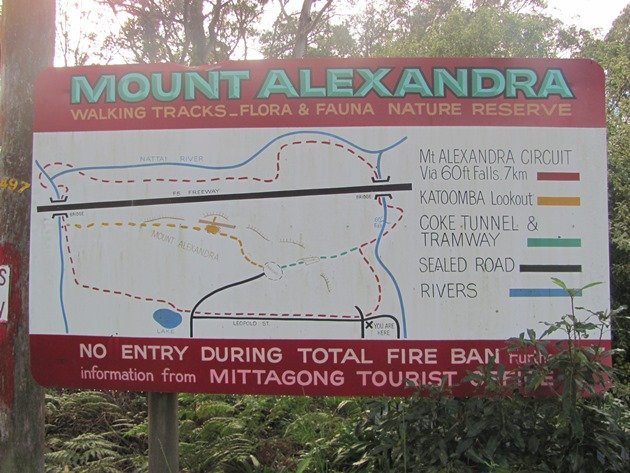
I am somewhere along the Nattai River, head down, covered in cobwebs, burrowing through spiky regrowth, supposedly on THE circuit route of Mount Alexandra that is shown on the faded old map at Lake Alexandra, and, I've lost the track, again. I recross the creek, look upstream, nothing, then back downstream – my foot tracks in a bit of clear sand by the river bank but no other indicator of passage. The book I have access to - “Discovering the Southern Highlands on Foot” - did mention crossing to the south bank of the Nattai River, so I go back again and fight my way through scrub, and, there a few metres above me is a vague track heading east, found again.

This was supposed to be an easy jog around Mount Alexandra on tracks, following this route that is displayed at Lake Alexandra, but, reality is not much like the sketch map. It all looks so clear and straight forward on the map. On the ground, it's a little different. The track along the Nattai River is overgrown and tough to follow and there are confusing track junctions all along the way and scant track signs. Below is my best guess of how to navigate the circuit without getting too terribly lost. I did have to backtrack a couple of times to “refind” the track.

Gibbergunyah Creek

Starting from Lake Alexandra, follow the paved track around the west side of the lake and take any one of several bush tracks that all join the main fire track that heads northwest along the eastern branch of Gibbergunyah Creek. Look out for a cement post with the top painted red that marks a foot pad descending to the creek. Follow this track until it joins another fire trail, and turn right to follow Gibbergunyah Creek north under the Hume Highway.

The next junction is easy to miss so keep an eye out for steps descending down to the creek on your left only a few minutes after passing under the Hume Highway. There is a sign, but it is down the foot track and not easily seen from the fire road. Cross Gibbergunyah Creek on a narrow cement foot bridge and head downstream with the river bank on your right. It is not very far to another sign where you cross the Nattai River on slimy rocks. Immediately across the river, the track actually forks, although it is virtually impossible to distinguish either fork. There are two signs, one pointing steeply up out of the river bed to the left, the other fallen down and buried in bush directs the walker to the right along the Nattai River.

Crossing the Nattai River

The track is hard to follow here as it is overgrown with fern and fallen trees. Keep the Nattai River to your right and look out for another crossing of the river to the south bank. I had to scout around to find the track here, maybe you will have better luck than me. When you do find the track, you'll be on the south side of the river with the river on your left. If you are counting, you have now crossed creeks three times in total.

For the next kilometre, the track is very overgrown and you'll be pushing through scrubby bush, climbing over fallen trees and trying not to lose the foot pad again. Gradually, the track gets clearer and easier to follow and you come out near a scraping where coal has been dug out. A steep track climbs up here, but the circuit continues straight ahead and, if you are on the right track, you should find some track markers along the next section. The track heads north following the river around a big oxbow and you are actually going away from Mount Alexandra at this point.

These signs could be superfluous if the track were cleared

Eventually the track turns back to the south and starts heading towards the highway and Mount Alexandra again. Soon, you can see the big highway bridge and you might begin to think all the tricky navigation is over, but it's not.

Pass under the Hume Highway (about 2 km east of the first passage under the highway) but don't take any of the tracks that climb up to the highway (at least one is marked by flagging). Instead, stay low and cross the Nattai River again on rock slabs. With the river on your right, follow the track as it climbs up to a viewpoint of 60 Foot Falls (often dry).

Upper Nattai River

Soon, the track joins a fire track. You should be heading south now with Mount Alexandra on your right hand side. The fire tracks gradually merge with other fire tracks but keep heading south and you'll be on track to return to Mittagong. You can take the low route and contour (on fire roads) around the south side of Mount Alexandra back to Lake Alexandra or you can grab a bit more training and hike up the Coke Tunnel track (look for the track to your right just after a fire road junction) back to the upper parking lot, then up the lookout fire track to the Boulder Valley track and back that way.   

Thursday, December 28, 2017

An Alternate Circuit of Mount Alexandra

If you walk around the NW side of Lake Alexandra, you will find a mouldy map showing a circuit route of Mount Alexandra. You could do this loop, which is just under 8 km long but you'll only accumulate, at best, about 100 metres of elevation gain. Here is a better circuit that runs over Mount Alexandra and garners about 400 metres of elevation gain in just under 6 km.

Follow the track around Lake Alexandra until you meet the main fire track heading NW along Gibbergunyah Creek. Turn left and continue along the fire road until a cement post (faded red top) marks a foot track that descends down into the creek valley on the right. This section is really nice along side a verdant creek with scattered sand-stone outcrops above.

Soon, the foot-track rejoins a fire track where you turn right and travel north along the east bank of Gibbergunyah Creek. Just before the track passes under the big highway bridges, a steep track climbs out on the right hand side. Follow this up to the top of Mount Alexandra, detour to Katoomba Lookout if you have not been before, and then continue down hill to the upper parking lot on Mount Alexandra. Watch for a cairn on the right as you descend as you will be coming back here later.

Behind a mangled gate, a very steep fire road runs generally southeast down to the lower edge of the reserve. Follow this downhill until you meet another fire road, turn left and look for a small track to the right that runs downhill to meet the main fire-road in the Nattai Valley. Turn left (north) and follow the fire track until you encounter the coke tunnel track on your left. The junction is unmarked but if you reach the fire road to 60 Foot Falls you've gone slightly too far.


Hoof it up the steep coke tunnel track back to the upper car park and keep going until you are almost at the top of Mount Alexandra again and look for the cairn on the left that marks the uphill end of the Boulder Valley track. Turn left and saunter down this track until you cross the fire road you started on and wander back to Lake Alexandra.

Tuesday, December 26, 2017

Around Mount Alexandra

I'm trying to keep jogging along the top of a road cut above the Hume Highway my feet on a mesh basket filled with rocks and the roar of Christmas holiday traffic assaulting my ears from 30 metres below. I would hate to topple down here; my head would be squashed like a ripe watermelon under the wheels of a speeding car, piloted by a hung-over, hypoglycemic father who already wishes the kids were back at school.

Why am I even here? This was supposed to be a training jog up and over Mount Alexandra, along the Nattai River, and back over Mount Alexandra all on tracks. Somehow, as so often seems to happen, I've been lured off the map, off the track, bashing through the bush because I don't want to go back.

Katoomba Lookout

It's surprisingly easy to find yourself off the map in the bush reserves around the Southern Highlands. I don't understand it. The little towns along this stretch of the Hume Highway must be wealthy – houses sell for millions of dollars - but the local reserves and parks are poorly maintained, ill-signed, and generally unloved. The district tourist information office does not even have a map of the local area tracks, focusing instead on pimping food, wine, and consumer goods in a nation where too many people are overfat and drowning in debt. As usual, money trumps everything.

But I am both figuratively and literally off track. From Lake Alexandra, I followed a bush track (if you look carefully you will find a broken down sign pointing to the Boulder Valley track on the uphill side of the fire road that heads west from Leopold Lane) uphill to the rounded top of Mount Alexandra. If you plan on coming down this track from Katoomba Lookout, watch carefully as there is no sign and only a fallen down cairn among greenery to mark the track. The Boulder Track joins a fire road that leads from the upper parking lot to Katoomba Lookout, but I turned right, away from the lookout, and jogged down to the upper parking lot.

Tunnel

A signed! track (“coke tunnel”) runs straight down the east slope of Mount Alexandra after passing through a coke tunnel. This track is very steep, eroded and joins the northern end of Leopold Street down near a tributary of the Nattai River.

I followed this fire road north to the 60 Foot Falls fire road junction where I stupidly took the verbiage on the sign “No Through Track” as literal truth and ended up followed Leopold Street to its terminus beside a big talus field above the Hume Highway. No problem, climbing over a fence I could see a bit of a track traversing the talus so I kept going. I knew from a previous trip that another steep track came down the NW ridge of Mount Alexandra to Gibbergunyah Creek which was only a kilometre away.

Then, the track and the talus ended and I was on the road cut above the Hume Hwy. Contouring west I found a steep paved drainage gully which I slithered down until I emerged on the Hume Highway. Gibbergunyah Creek bridge was now a mere 100 metres away so I jogged along the highway to that, but, the highway bridge is about 70 metres above the creek and the track under the bridge with no easy or even safe way down.


Heading back, I found another drainage gully this time heading uphill and west, so I scrambled along that until it ended, then headed into the scrappy bush. Some easy bushwacking, a clamber over a fallen down fence and I was on the track that comes over Mount Alexandra. I had not previously been right down to Gibbergunyah Creek so I hiked down the steep, but constructed track to the fire road where I even found a sign. From there, it was a simple matter to hike back up the track past Katoomba Lookout and back down the Boulder Valley Track.   

Wednesday, December 13, 2017

2018

2017 is slipping through our fingers as quickly as a rational thought slides off the angry orange man's cerebral cortex. That means it is time for Doug and I to wish you all health, happiness, and sustainability for 2018. We hope you enjoy a few pictures and stories from our last year, but we would get greater pleasure from hearing about your 2017, so please send us your Christmas letters and pictures.

Wild islands off the Queensland coast

March was extraordinarily rainy in eastern Australia, and it wasn't until the end of March that we got away in our caravan again. We paddled out to Broughton Island, a favorite with sea kayakers, then detoured south to climb, canyon and bushwalk in the Blue Mountains World Heritage area.

Doug in pagoda country, Blue Mountains area

Heading north we visited a series of wonderful National Parks in northern NSW where we descended into steep sided rock canyons, followed brumby paths along meandering rivers, and walked beside precipitous rocky spires.

Deep in Oxley Wild Rivers National Park

Queensland was mostly about sea kayaking. Over a series of multi-day trips with different groups of friends we covered around 800 km of coastline, with literally hundreds of humpback whale sightings.

Whoa!

Our earth is precious, as is our health, look after both in 2018.


Looking down on kayak camp