Camping on High Peak Island is very remote, 160 kilometres north of Yeppoon, 180 kilometres south-east of Mackay and can be reached by boat only. Broad Sound Islands National Park website.
Preamble:
High Peak Island is out there, the most easterly island along the Capricornia Coast. Plunked down in the middle of a big deep ocean with tidal heights reaching nine metres and nearby only a smattering of small islands and islets none of which are amenable to landing a sea kayak. The nautical chart for the area is liberally marked with the symbol for overfalls, tide rips and races, and, my personal favorite: “position of island is approximate.” And, if one needed any further reasons to visit, we knew of no other kayakers who had ventured that far east.

But, as Boromir said in The Fellowship Of The Rings, “one does not simply” paddle out to High Peak Island. Any trip through the Shoalwater Bay Military Exercise Area requires careful planning. Fresh water is scarce, tides are massive, currents are strong, overfalls, tide rips and races appear and disappear depending on wind and tidal conditions but are overall ubiquitious, the trade winds can be strong and persistent, mobile telephone and radio reception poor to non-existent, and civilisation far away.

PC: DB
While Doug loaded Plotyak™ onto his computer and got down to the serious business of plotting bearings for crossings and departure times, I proceeded with the more mundane and prosaic work of drying more dinners, making batches and batches and batches of lentil crackers, and increasing our supply of water bags from five to ten enabling us to carry in excess of 50 litres of water when required. A start date was chosen to ensure we were paddling the more difficult crossings with smaller tides and the inevitable car shuffle sorted.

There is no getting around the long drive north from the south coast of NSW to the Capricornia coast in Queensland. On the way up, we operated on the assumption that four shorter days was better than three longer days, but reversed that on the way back. In retrospect, I think I prefer three shorter days. There is some pleasure in getting such an unpleasurable activity over as quickly as possible, and good places to stop for the night along the way are lacking. My definition of a good place to overnight is a quiet and uncrowded caravan park without bright lighting but with a decent camp kitchen, away from the endless grind of road trains which characterise Queensland roads, and with some nearby natural area where one can walk off the stress of the days driving. In my estimation, there are two places that meet these criteria on our long route north: Wellington Caves Campground – run by the local council and just wonderful – and Isla Gorge National Park.

We met up with FishKiller Pearson – also known as the “bubble of chaos” - after our latest experiences paddling the Capricornia coast with FishKiller - at the BarraCrab Caravan Park at Clairview. The BarraCrab is a bit of an odd caravan park, strangely popular given the locale, the facilities, the meals from the cafe, the rigamarole required to book, and the disappearing and cloudy water (the tide goes out a very, very long way) that fronts the beach, but, there is a small sand boat ramp, and the shuttle back to Bangalee to start the paddle is shorter than finishing the trip at any of the small towns further north. The large tides and flat beaches along this section of the Queensland coast mean that all trips must end at or very near high tide to avoid very long carries across mudflats.

The first hurdle of the trip was getting three boats on FishKiller’s roof racks and all our kayaking and camping gear, including about 30 litres of water and two weeks food into the interior of the car along with three people. This took more hours than I like to think about and was facilitated by the wooden extensions to FishKiller’s roof rack which Doug had constructed at home. After this was finally achieved, we retired for our last night in civilisation.

Day 1: Bangalee to Little Corio Bay
With northerly winds forecast for the first several days of the trip, we had realistic plans for heading north up the coast and had planned just 16 kilometres for our first day. Unlike the previous year, launching from Farnborough Beach at Bangalee was easy and we paddled north following the beach up to Sandy Point, across the mouth of Corio Bay – which was a mess of breaking waves last year – and landed at beautiful Little Corio Bay with pandanus trees for shade, a kilometre long white sand beach and an easy walk up onto the height of land where native flowers flourished and the sunset over Corio Bay was stunning. The relief at being out of the car, away from civilisation and at the start of two weeks of wilderness paddling was immense.

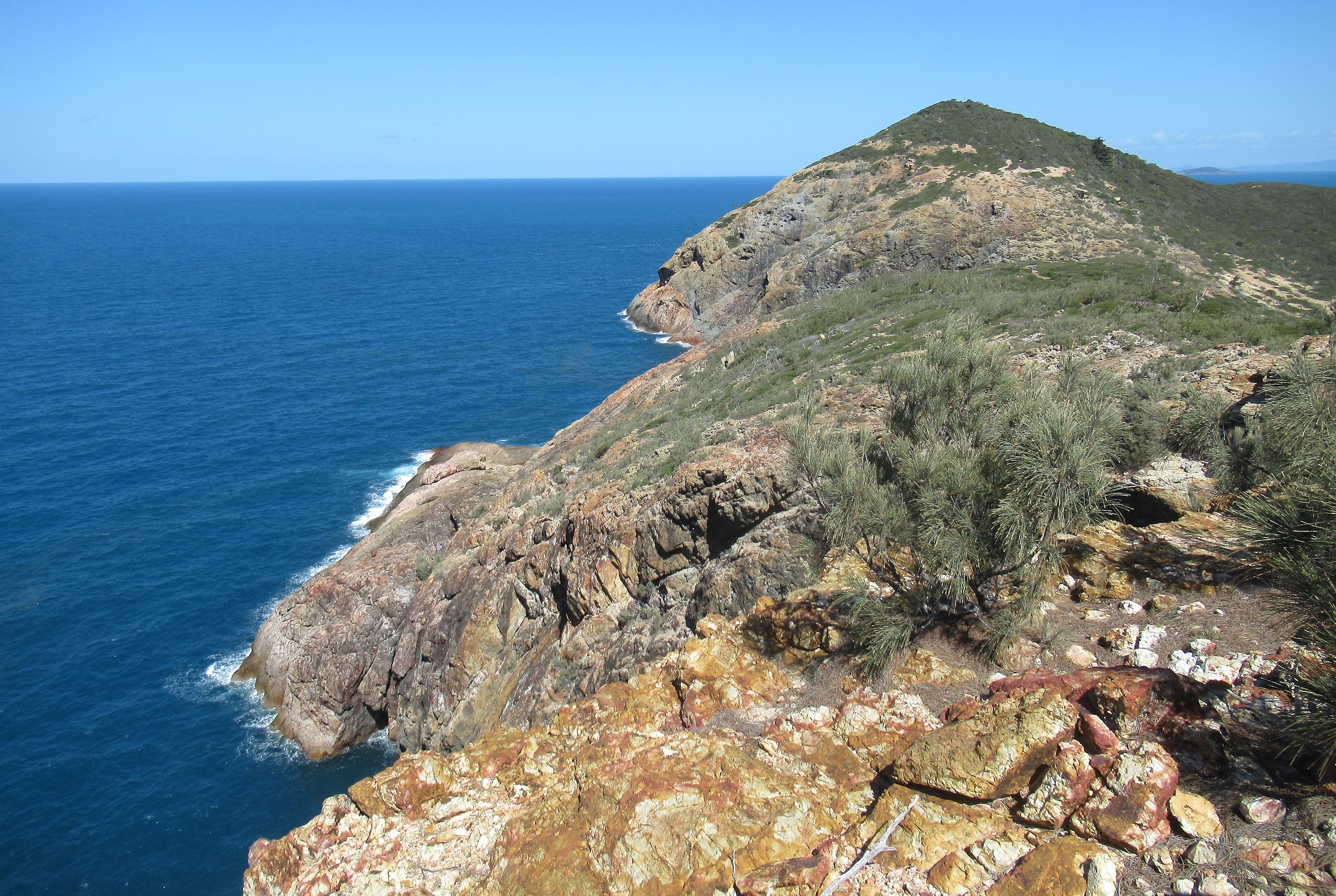
Day 2: Little Corio Bay to Three Rivers
We start the day paddling north around Water Park Point which has a big cave on the eastern side, even FishKiller follows the rocky coastline closely. Then it is a steady paddle north into a light headwind beside Nine Mile Beach until we reach Stockyard Point where there is once again interesting rocky coastline bisected by sea carved corridors of rock to explore. At Five Rocks we land the kayaks and walk the short distance up the track to spring and waterfall that miraculously bursts out of this dry landscape.

Water bags are filled and salty bodies washed before we continue paddling north. The previous year we struggled to find an easy landing site along this coast but today conditions are so calm we paddle through a tiny gap in the rocky reef that separates Five Rocks from the beach. Five Rocks Beach is about five kilometres long and marks the start of the Shoalwater Bay Military Excercise Area. Beyond this point there are no roads but minor military roads, no settlements, no people.

With calm seas and just a light headwind, we paddle close in along the shore enjoying the many interesting gauntlets carved into the bedrock. We are looking for a good campsite, any one of the small beaches along this section of coast will suit. At the back of the first small beach we reach, a small waterfall can be seen bursting out of pandanus trees. “This is tonight’s camp,” we all agree quickly. A pretty beach framed by rocky headlands and a gushing freshwater waterfall are too good to pass by. Landing the boats, we walk up to the waterfall which has a deep pool at its base. The only downside of the camp is the masses of plastic garbage washed up at the back of the beach. These easterly facing beaches collect the plastic detritus of the world. Carefully picking up our used tea bags to carry out with us seems futile among the plastic debris, but we can at least not add to the garbage.

Day 3: Three Rivers to Port Clinton
Before leaving Three Rivers we filled all ten of our water bags, a two litre bottle and our PFD bladders totally about 60 litres of water distributed between our two kayaks. Doug’s boat was so heavy I could barely move it! The boats did feel ponderous and heavy as we paddled north towards Cape Manifold but the scenery is so good, the water so calm and clear that we soon forget how heavy our boats are and just enjoy the spectacular environment.

We find a big slot on the first headland north of Three Mile and then a series of small, pretty bays separated by rocky headlands before we reach Cape Manifold where the coast turns abruptly west. There are a number of gauntlets that cleave the rocks of Cape Manifold and we choose one to paddle through meeting up with FishKiller, who, as is normal practice for him, has paddled straight to Cape Manifold. At Cape Manifold we encourage FishKiller to continue on to find a camp site near Port Clinton so that we can fully explore the coast as we travel north. Off he goes soon becoming a speck in the distance.

Doug and I paddle along the north side of Cape Manifold and across to Cliff Point where tall cliffs fall straight into the sea and a female Humpback Whale with a calf is slowly swimming along the cliff. We squeeze in close to the cliffs, the conditions are so calm I can reach out and touch the rocks, while the whales rest nearby. From Cliff Point we head straight north to Quion Island and paddle through the calm, deep passage that separates a mini Quoin Island (unnamed) from Quion Island on the south side. Quion Island has 30 metre high columnar basalt cliffs on the east side and is spectacular.

The northern three to five kilometres of Cape Clinton is riddled with massive sea caves and conditions are perfect for exploring them all. The first cave we paddle into is so deep that the back is completely dark and would require a headlamp or torch to reach the end. There are caves with big openings and caves with small openings, narrow caves, wide caves, slots, gauntlets, passage ways, we expore them all, paddling through narrow passages and backing into dark caverns. The conditions are amazing and we wish Nick were here as he would love this coastline.

Eventually, after 30 kilometres we paddle past Cape Clinton, paddling through one last slot, to find FishKiller eating oysters on a northerly facing beach. FishKiller has been amazingly patient not unpacking his boat as he waited for us to dally our way up the coast, and we quickly decide this beach is good enough. There are so many good campsites on this coastline and so much to see and explore that you could spend three weeks just getting to Stanage.

Day 4: Port Clinton to Island Head
The predicted northerly winds had been kind. Although present, the wind never exceeded about 10 knots so even with heavy boats we were doing fine, but day four, the northerly winds were forecast to increase ahead of strong northerlies the following day. FishKiller, having once caught a fish at Island Head, was determined to return to camp on the island and perhaps catch the biggest fish of his entire career.

Our original plan, conditions permitting, had been to paddle north via Split and Dome Islands – the location of many caves, tunnels and arches – and paddle by the small but scenic looking Clara Group of islands on our way north. This route would put us into the brunt of the northerly winds so we settled for paddling up the coast instead.

Our first stop would be a small beach marked on the topographic map with “Flinders Watering Gully.” How could there not be water at such a place? The previous year, conditions had been too rough to approach the location as strong tidal outflows collided with a solid southeasterly sea driven along by moderate winds and we had instead passed by outside of shifting sandbars and breaking waves.

At Flinders Watering Gully we found a small beach and water. A very deep pool below a trickling creek in a deep shady gorge. Not much water coming in and only a small trickle running through and out but clear fresh water nevertheless. We refilled our containers, dunked into the pool, and continued paddling north passing inside Rankin Islet in very calm sea conditions. Sadly, we passed by the mouth of beautiful Delcomyn Bay, which we had luckily been able to explore the previous year, and at Pearl Bay we passed east of the few small islands that cluster near the south end and then straight north to another stunning section of coast.

The final six kilometres to Island Head the paddling just got better and better. A few small beaches tucked between headlands but predominantly cliffs, rock islets, gauntlets, passages and corridors all off-set by a solid blue sky and clear, clear water. We passed turtles, dolphins, whales and sharks. The last northerly facing beach before Island Head would make a wonderful campsite surrounded by steep columnar cliffs that fall straight into the sea.

Strong tidal currents swirl around Island Head, there are shifting sandbars and you can generally catch a single wave and ride it for upwards of half a kilometre. FishKiller was tucked into a corner on the mainland patiently waiting for Doug and I to arrive from our dalliances under the big cliffs, and we crossed over the swirling currents to land on the eastern sandspit at Island Head.

The campsites were a bit scrappy as steep vegetated ground comes right down to the high tide mark, but we both found a suitable spot for our tents and had our usual afternoon swims. That evening, FishKiller did indeed catch a fish which was very tasty but he seemed less than enamoured with the idea of catching more. The entire clean, gut, cook procedure hardly seeming to offset the possibility of eating fresh fish.

Day 5: Island Head
The northerly winds blew in as forecast. Our rest day, which was otherwise enjoyable, was interrupted by endless moves from one part of the beach to another to try to find some shelter from the wind where we were not getting unwanted facials from blowing sand. Doug and I both walked up to the top of Island Head which was surprisingly easy if you used a bit of common sense. An easy walk up to a broad saddle and then eastward to the top. The only difficulty was some thick scrub on the summit which had to be skirted on the north. The views were excellent.

FishKiller, in his usual “bubble of chaos” fashion set off to fish from a rock platform at the southern end of the island and, with fishing rod in one hand, fishing net in the other, and with extra clothing tied like nappies around his waist proceeded to lurch across the steepest part of the hill side to reach the exposed rocks. Watching this ignominious traverse, I strolled around on the rock platforms below.

My kayak had been leaking into the back hatch every day of the trip so Doug carefully dried the keel and stuck on some “gaffer tape.” The resulting repair was tested with a few litres of water from an unbroken bucket found around the island. The bucket, which will feature briefly again in this account, was kept full of sea water and near our camp to facilitate washing up. Overnight, the sound of the waves breaking on the sand spit was so loud that Doug and I both put ear plugs in to aid in sleep, which is likely how we did not come to notice, until morning, the metre of sand that had been lost to the sea overnight. Doug’s kayak was within 30 centimetres of being washed away, mine not far behind and the bucket, still full of water left precariously on 30 centimetres of remaining sand.

Day 6: Island Head to Bomb Crater Bay, Townsend Island
Finally, after nearly a week out paddling, it is time to paddle north to the premier destination of the trip, High Peak Island. High Peak Island is 42 kilometres due north of Island Head. Earlier Plotyak™ calculations had indicated we should leave around 9 am for the crossing to maximise the benefit of tides. This could be pushed back as far as 10 am, but, that would put our arrival time at around 4:00 pm, provided nothing went wrong, with a smaller window of remaining light than ideal.

Overnight, the northerlies, as predicted, had swung southerly and at Middle Percy Island the wind was blowing near 30 knots. From our last trip, we knew exactly what 30 knots of wind on the various currents would do to the sea state. Breaking waves could easily reach two metres or more. Our alternate route was to paddle north up the east side of Townsend Island to camp in a bay near Raynham Island. The following day, with winds forecast to moderate, we would paddle 37 kilometres northeast to High Peak Island. The wind direction would not be quite as favourable but we should still get some assistance from our kayak sails.

As we had only a short day ahead, we decided to detour over to Pine Trees Point to see if we could find the elusive fresh water supply which we had been unable to locate on our two previous trips up this coast. Years before, FishKiller had not only got good water but the group had also had fresh water dips in a deep pool. Accordingly, we landed on the beach and made our way up a dry creek bed to a dry waterfall. There was a small pool of skanky water at the base, but forays above the waterfall revealed no water further up. Doug remembered checking this drainage the year before when it had been completely dry. Finally, the mystery of the Pine Trees water was solved. Good rain immediately before the trip is a necessary condition of finding good water.

From Pine Trees Point we passed by the entrance to Strong Tide Passage and paddled, with sail assistance, north up the east coast of Townsend Island. Townsend Island does not have the steep cliffs found further south, but the coastline is lovely. Small sandy bays, rocky headlands, caverns and caves to peer into, and prolific marine life. Pairs of Humpback Whales – females with calves – were resting in shallow bays, turtles were everywhere, a pod of 30 or 40 dolphins were hunting, sometimes leaping completely clear of the water, and four sharks were cruising up and down the beach in shallow water when we landed.

Day 7: Bomb Crater Bay to High Peak Island
Our most committing crossing of the trip because, although High Peak Island is only around 40 kilometres northeast of Townsend Island, it is 120 kilometres east of the mainland Queensland coast. Plotyak™ had charted a course which would take us close to Rothbury, Tweed and Berwick Islands, all small inhospitable islands with no suitable landing places. This was the only navigational mistake of the trip as the waters around these small islands are full of overfalls and tide races and rips. Passing to the north of Tweed Island would have been much less risky.

Leaving Bomb Crater Bay conditions were strangely calm but within an hour we were into steep seas, a brisk wind, and sections of what I can only call “squirrelly water” where the waves would abruptly increase in size and steepness. As we approached Rothbury Island, the sea got rougher and rougher and large breaking waves were visible to the south and east of Rothbury Island. Doug, our chief navigator, called for a change of direction and we turned further to the north to paddle between Rothbury and Tweed Islands. We literally surfed into the gap between the two islands with large breaking waves on our eastern side, each of us responsible for keeping the keel side of our kayaks down – a rescue in these conditions would be difficult.

On the northern tip of Rothbury Island we found a tiny space of lee shelter and stopped to regroup before the final eight kilometres to the beach on High Peak Island. Raunchy conditions continued until we passed Berwick Island with more tide races and overfalls. As we neared the southern tip of High Peak Island, sea conditions eased leaving us with a stiff headwind to reach the beach.
She Oaks created shade at the back of the beach and we found camp sites in the bush. But, walking between our kitchen area and our tent, I discovered a pile of human faeces and about three rolls of toilet paper strewn around. This would not be the first time, nor the last, on this trip. Piles of poo and toilet paper distributed by person(s) unknown which we dubbed the “Capricornia Crapper.” Modern humans would die without modern society as a good chunk of people alive today have no idea how to manage such simple matters as human waste. Distasteful as the scene was, I cleaned the mess up, burning the toilet paper, burying the shit, and pouring a couple of pans of sea water onto the entire mess.

Day 8: High Peak Island
We were determined to have a day to enjoy High Peak Island and not merely arrive and leave the next day on our journey west. Doug made a magnificent loop of the two high points on the southern side of the island. Walking up slabs to the south of camp, he reached a 100 metre high saddle on the east side of the island. The easterly winds were blowing strongly, but he continued scrambling rocks to reach 130 metre high point at the southeast end of the island and then dipping westward into another saddle and walking to the top of the most westerly high point. The views were fabulous as the east side of High Peak Island features a series of steep cliffs cut by rocky saddles.

I walked north from camp following steep rock slabs around to Camp Cove, a broken coral beach facing north. Whales were swimming idly off the west side of the island and a pod of perhaps 50 dolphins were leaping clear of the water. Later, I followed Doug’s route up to the eastern saddle and wandered north along slippery exposed rocks to peer into deep chasms and over steep cliffs on the exposed side of the island. FishKiller went out in the boat for some fishing, caught no fish, but did watch sharks swimming in the shadows and had a close encounter with the pod of feeding dolphins.

Day 9: High Peak Island to Hexham Island
High Peak Island has a fringing coral reef which dries at low tide which could have presented some problems for leaving in the morning but we put our boats right at the reef line and, by the time we had packed in a desultory manner, the tide had risen enough to cover the reef and we could float out. With wind and tide assistance, the 32 kilometre crossing to Hexham Island was relatively easy. After 10 kilometres we passed rocky Morpeth Island, and a further 21 kilometres brought us to the steep orange cliffs on the southern end of Alnwick Island. We paddled past Shields Island and landed on the northerly facing beach on Hexham Island.

Hexham Island is only 40 kilometres from the fishing community at Stanage and there were a couple of recreational boats fishing off the western headland, and, more disappointingly, the Capricornia Crapper had recently been to the island and multiple piles of human feaces and soiled toilet paper were in the bushes behind the beach. This time FishKiller had the distasteful job cleaning up.

Hexham Island has good mobile telephone reception from the hill to the west of the beach. There is even a faint footpad leading up. In the evening, I went up to pick up the weather forecast instead of Doug. Had Doug done this, as was his normal habit, we would have found out we were listed as “missing persons” a day earlier. Although the beach at Hexham Island had been eroded by the northerly winds, it was still wonderful swimming.

Day 10: Hexham Island to the Duke Islands
From Hexham Island we continued almost due west to the Duke Islands. The Duke Islands Pastoral Company owns three of these islands – Marble, Tynemouth and Hunter – and runs cattle on the islands. We paddled through the group to an isolated camp for the evening. Again, we were treated to an easy crossing with the wind at our backs and tidal assistance.

Day 11: The Duke Islands to Wild Duck Group
As far east as Duck Island, the tidal current runs east to west. West of Duck Island, the tidal current begins to run north to south to flood and drain the massive Broad Sound. Peak currents reach over three knots, a speed with which a kayak cannot compete. Plotyak™, however, was able to give us reasonably accurate times to leave to catch the best currents and soon another 30 kilometre crossing was finished.

Wild Duck Island has a freshwater lagoon where you can actually swim not just plunge, so we enjoyed that facility before finding a campsite for the night.

Day 12: Wild Duck Group to Flat Isles
Paddling west from the Wild Duck Group we would no longer have tidal assistance. “Plotyak™ is no use to us anymore,” Doug sadly opined. We had another crossing, this one in the region of 20 to 25 kilometres to the Flat Isles. At the Flat Isles we would be within 20 kilometres of the coast, a fact that was both cheering and depressing at the same time. Heartening, as Doug and I were thoroughly sick of our dinner “slop”, but saddening because this wonderful trip was nearing the end.

As we paddled west with sails up and a modest tail wind, FishKiller remarked “There may be a storm coming.” I looked around and noted grey clouds lowering on the southern and eastern horizon. With Doug’s assistance to raft up, the seas being somewhat bumpy, I put my cagoule on, but Doug was confident nothing would eventuate. “FishKiller is mad,” he said confidently. We continued paddling, our sails filling with more and more wind until, in an instant, the squall hit. The wind quickly increased to 25 knots, the seas churned up into steep breaking waves, and suddenly we were all just hanging on, surfing down waves, bracing for support on one side, then the other. It began to rain, heavy pelting rain and we fought to keep sight of one another. Soon, we were well separated from FishKiller and Doug and I pulled our sails down.

FishKiller appeared to our northern side, and we agreed to paddle without sails until the worst of the squall had passed. The wind was driving us straight towards the Flat Isles but was also blowing across a northerly running current so the seas were big. Paddling without sails we felt slow, but likely weren’t, but were at least in control. We were still running down the face of waves but avoiding broaching was easier. As the winds eased to 20 knots, we decided to try sailing again, but Doug’s sail had fallen off his mast, so I had to raft up with him to fix that. Sails up, we began speeding towards the Flat Isles again. Gradually, however, the rain stopped, the wind eased, and we arrived at a somewhat exposed campsite with winds just under 20 knots. That afternoon, both Doug and I had good wanders around the island. The wind, however, was a bit abrasive at camp.

Day 13: Flat Isles to Clairview Via Roundish Island
In a straight line, we were about 20 kilometres from Clairview where our car was parked but, between us and Clairview was a forecast of continual southerly winds, northerly tides, and, of course, the inevitable need to arrive at Clairview at or very near to high tide to avoid being unable to land. We floated options that ranged from leaving at 4 am to leaving at 4 pm, none were completely satisfactory given the forecast for moderate southerly winds.

At 4.30 am, when I got up, the waves were crashing onto the beach and a modest southerly was blowing. Nevertheless, we got up, readied for departure and headed south. Our back up plan was stopping on Roundish Island or possibly Flock Pigeon Island, although, if we got as far as Flock Pigeon Island we would have paddled the 21 kilometres to Clairview.

Wind on tide had created steep waves and with each paddle stroke it felt as if the kayaks came to a dead stop and had to be restarted again. In the southeast, more squally weather looked possible, and I dreaded the prospect headwinds as strong as we had encountered the previous day. Luckily, the squalls seemed to ameliorate as they approached but we had a long, slow paddle to Roundish Island, the 10 kilometres taking 2.5 hours. At Roundish Island, we were lucky enough to find a spit of sand among the boulders where we could land the kayaks. In a desperate situation we could also scratch out a camp.

We spent three or four hours on Roundish Island. With the tide now running solidy north at a couple of knots and a 15 to 17 knot headwind, reaching Clairview would be either a long drawn out affair or more likely impossible. Around 1:30 pm, we noticed that the wind was no longer roaring over the back of the island, and, walking around to the south, the sea state was rapidly calming. We repacked the boats, slowly. Doug wanted to wait until 4:00 pm to leave but the wind was forecast to blow in at 20 knots from the east by 4:00 pm and I wanted to leave sooner than that.

Two weeks of packing and unpacking boats meant we were expeditious even while trying not to be that by 2:00 pm we were ready to go. The final 12 kilometres to Clairview was completed in the calmest conditions we had the entire trip! Although the tide was still out when we arrived, paddling south along the coast just to the north of Clairview we found a spot where someone had removed enough rocks to fashion a sandy landing and we pulled the boats out onto a small beach near a bus stop and park, 13 days and some 300 kilometres after leaving Bangalee. Another magical trip along the Capricornia coast marred only by several encounters with the California Crapper.

Denoument:
While FishKiller and I carried boats and gear, Doug walked 1.5 kilometres south to retrieve our car, now gaudily festooned with “Police Aware” and “missing person” signs, and to order us dinner from the BarraCrab cafe. By the time Doug got back, FishKiller and I had carried up all three boats and had begun sorting and packing gear. The long process of putting three boats on a roof rack designed for two was interrupted near the end by a call from the cafe to tell us our take out was ready. Sitting in a bus stop, salty and tired, we ate one of the most disgusting take out meals I have had the misfortune to encounter. A cardboard box filled with chips fried in rancid industrial seed oils and a sad piece of meat cooked in the same poison. Not a lettuce leaf or slice of tomato as accompaniment. We were, however, ravenously hungry and ate every bite, but Doug felt sick all night and I woke feeling like the California Crapper myself.

No comments:
Post a Comment